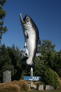
Rakaia is a town sited on the southern banks of the Rakaia River on the Canterbury Plains in New Zealand's South Island, approximately 57 km south of Christchurch on State Highway 1 and the Main South Line. Immediately north of the township are New Zealand's longest road bridge and longest rail bridge, both of which cross the wide shingle beds of the braided river at this point. Both bridges are approximately 1,750 metres (5,740 ft) in length.[citation needed]
Rakaia | |
|---|---|
town | |
 The Big Salmon of Rakaia | |
 | |
| Coordinates: 43°45′S 172°01′E / 43.750°S 172.017°E | |
| Country | New Zealand |
| Region | Canterbury |
| Territorial authority | Ashburton District |
| Ward | Eastern |
| Electorates |
|
| Government | |
| • Territorial authority | Ashburton District Council |
| • Regional council | Environment Canterbury |
| • Mayor of Ashburton | Neil Brown |
| • Rangitata MP | James Meager |
| • Te Tai Tonga MP | Tākuta Ferris |
| Area | |
• Total | 11.30 km2 (4.36 sq mi) |
| Elevation | 108 m (354 ft) |
| Population (June 2024)[2] | |
• Total | 1,730 |
| • Density | 150/km2 (400/sq mi) |
Rakaia was also the junction of the Methven Branch, a branch line railway to Methven that operated from 1880 until its closure in 1976. An accident at the railway station in 1899 killed four people.[3]
Rakaia's most obvious feature is a large fibreglass salmon. The river from which the town takes its name is known for its salmon fishing and jetboating.
The town and river were previously known as Cholmondeley,[4] but the Māori name would eventually prevail over the English one.
The rural community of Acton is located south of the Rakaia township.[5]
Demographics
editRakaia is described by Statistics New Zealand as a small urban area and covers 11.30 km2 (4.36 sq mi)[1] and had an estimated population of 1,730 as of June 2024,[2] with a population density of 153.1 people per km2.
| Year | Pop. | ±% p.a. |
|---|---|---|
| 2006 | 1,071 | — |
| 2013 | 1,272 | +2.49% |
| 2018 | 1,440 | +2.51% |
| Source: [6] | ||
Rakaia had a population of 1,440 at the 2018 New Zealand census, an increase of 168 people (13.2%) since the 2013 census, and an increase of 369 people (34.5%) since the 2006 census. There were 576 households, comprising 723 males and 720 females, giving a sex ratio of 1.0 males per female. The median age was 42.3 years (compared with 37.4 years nationally), with 303 people (21.0%) aged under 15 years, 225 (15.6%) aged 15 to 29, 657 (45.6%) aged 30 to 64, and 255 (17.7%) aged 65 or older.
Ethnicities were 86.9% European/Pākehā, 12.9% Māori, 5.2% Pasifika, 3.3% Asian, and 1.7% other ethnicities. People may identify with more than one ethnicity.
The percentage of people born overseas was 12.3, compared with 27.1% nationally.
Although some people chose not to answer the census's question about religious affiliation, 53.1% had no religion, 34.8% were Christian, 0.6% had Māori religious beliefs, 0.4% were Hindu, 0.2% were Muslim, 0.6% were Buddhist and 1.9% had other religions.
Of those at least 15 years old, 93 (8.2%) people had a bachelor's or higher degree, and 330 (29.0%) people had no formal qualifications. The median income was $33,500, compared with $31,800 nationally. 135 people (11.9%) earned over $70,000 compared to 17.2% nationally. The employment status of those at least 15 was that 636 (55.9%) people were employed full-time, 162 (14.2%) were part-time, and 24 (2.1%) were unemployed.[6]
Notable buildings
editSaint Mark's Anglican Church
editSaint Marks was built in 1877. It was designed by architect Benjamin Mountfort in a Gothic style. It is considered a typical example of the wooden churches he designed for small parishes. The church was listed as a category two historic place in 1992.[7]
Rakaia Post Office
editThe Rakaia Post Office was built in 1910.[8]
Bank of New Zealand
editThe Rakaia Bank of New Zealand building.
South Rakaia Hotel
editThe South Rakaia Hotel is almost 150 years old.[9]
St Andrews Presbyterian Church
editReferences
edit- ^ a b "ArcGIS Web Application". statsnz.maps.arcgis.com. Retrieved 3 November 2021.
- ^ a b "Aotearoa Data Explorer". Statistics New Zealand. Retrieved 26 October 2024.
- ^ McLintock, A. H. (1966). "Rakaia Railway Accident". An Encyclopaedia of New Zealand. Retrieved 27 November 2011.
- ^ "Names of Places, Fights for Priority". The New Zealand Herald. 1 May 1934. Retrieved 24 June 2018.
- ^ Acton, New Zealand on GeoNames.org
- ^ a b "Statistical area 1 dataset for 2018 Census". Statistics New Zealand. March 2020. Rakaia (337600). 2018 Census place summary: Rakaia
- ^ "Search the List | St Mark's Church (Anglican) | Heritage New Zealand". www.heritage.org.nz. Retrieved 7 November 2021.
- ^ "PRESS, VOLUME LXVII, ISSUE 14018, 15 APRIL 1911". paperspast.natlib.govt.nz. Retrieved 18 October 2020.
- ^ "The Country Pub: The South Rakaia Hotel". Stuff. 29 December 2014. Retrieved 18 October 2020.