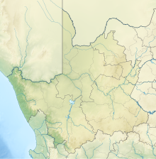
Copperton was a mining town in the central Karoo region of South Africa. As a copper and zinc-mining area, Copperton saw its heyday between 1970 and the end of the 20th century, when it housed about 3,000 workers and their families; amenities included a school and recreation facilities, including a golf course.[1]
History
editThe copper-zinc mine at Copperton, which had been opened in 1972, was shut down in 1991 by the Anglovaal Mining Group.[2] The 2011 census found 57 inhabitants.[3] Today, most of the buildings have been demolished and only a few houses are used by Armscor, who operate a weapons testing center, Alkantpan Test Range, in the area.[1]
Renewable Power
editSeveral new renewable energy projects (solar and wind) have been allocated through the REIPPPP and these projects will be constructed in the vicinity of this town.
| Power plant | Province | Date commissioned (planned) |
Installed Capacity MW (planned) |
Type | Status | Coordinates | Operator | Notes |
|---|---|---|---|---|---|---|---|---|
| Copperton Windfarm | Northern Cape, Copperton | (late 2017) | (102) | Wind | Contracting | 29°54′30″S 22°20′45″E / 29.908267°S 22.345848°E | Gestamp Wind | [4][5][6] |
| Garob Wind Farm | Northern Cape, Copperton | (Oct 2018) | (136) | Wind | Contracting | 29°55′44″S 22°24′06″E / 29.928871°S 22.401696°E | Enel Green Power | [7] |
| Mulilo Renewable Energy Solar PV Prieska | Northern Cape, Copperton | 1 October 2014 | 19.93 | Solar PV | Operational | 29°57′56.4″S 22°18′53.2″E / 29.965667°S 22.314778°E | Mulilo Renewable Energy | [8] |
| Mulilo Sonnedix Prieska PV | Northern Cape, Copperton | (Dec 2015) | (75) | Solar PV | Under Construction | 30°1′27.86″S 22°21′44.02″E / 30.0244056°S 22.3622278°E | Mulilo Renewable Energy | [9] |
| Mulilo Prieska PV | Northern Cape, Copperton | (Nov 2015) | (75) | Solar PV | Under Construction | 30°2′2.96″S 22°19′10.93″E / 30.0341556°S 22.3197028°E | Mulilo Renewable Energy | Area: 205 hectares (2.05 km2) [10] |
See also
editReferences
edit- ^ a b "Copperton". Tracks4Africa Padkos. Retrieved 25 January 2014.
- ^ "Proposed Pv2-11 Photovoltaic Energy Plants On Farm Hoekplaas Near Copperton, Northern Cape" (PDF). South African Heritage Resources Agency Information System. p. 55. Retrieved 25 January 2014.
- ^ "Main Place Copperton". Census 2011. Retrieved 25 January 2014.
- ^ Change, United Nations Framework Convention on Climate. "CDM: Copperton Wind Farm (Mabanaft-SA-Wind-001)". cdm.unfccc.int. Retrieved 22 September 2015.
- ^ "COPPERTON WIND ENERGY FACILITY BIRD IMPACT ASSESSMENT" (PDF).
- ^ "Project Design Document (PDD)" (PDF).
- ^ "NERSA Hearing 20 February 2014 Garob Wind Farm" (PDF).
- ^ "Mulilo Renewable Energy Solar PV Prieska" (PDF). Retrieved 18 August 2013.
- ^ "Mulilo Sonnedix Prieska PV (PTY) LTD 75MW Solar PV Power Plant" (PDF). Retrieved 18 April 2015.
- ^ "Mulilo Prieska PV (PTY) LTD 75MW Solar PV Power Plant" (PDF). Retrieved 18 April 2015.
