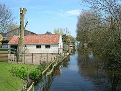
Bangert is a neighbourhood of Andijk and former village in northwest Netherlands, located in Medemblik, North Holland.
Bangert | |
|---|---|
Neighbourhood and former village | |
 | |
| Coordinates: 52°44′9.72″N 5°10′41.1″E / 52.7360333°N 5.178083°E | |
| Country | |
| Province | North Holland |
| Municipality | Medemblik |
| Village | Andijk |
| Area | |
| • Total | 0.73 km2 (0.28 sq mi) |
| Elevation | −1.3 m (−4.3 ft) |
| Population (2021)[1] | |
| • Total | 1,370 |
| • Density | 1,900/km2 (4,900/sq mi) |
| Time zone | UTC+1 (CET) |
| • Summer (DST) | UTC+2 (CEST) |
| Postal code | 1619[1] |
| Dialing code | 0228 |
Throughout its history Bangert has been competing with surrounding municipalities (esp. Andijk and Kerkbuurt) for land and population. For instance, in 1667 neighbouring Kerkbuurt acquired a church and began pulling away some of Bangert's inhabitants. In the 19th and 20th centuries, poverty combined with landgrabbing by Wervershoof also diminished the village.[citation needed]
Andijk annexed Bangert, Kerkbuurt and Munnikij which are now considered neighbourhoods of Andijk. In 2011, it became part of the Medemblik municipality.[3]
References
edit- ^ a b c "Kerncijfers wijken en buurten 2021". Central Bureau of Statistics. Retrieved 1 May 2022.
- ^ "Postcodetool for 1619AA". Actueel Hoogtebestand Nederland (in Dutch). Het Waterschapshuis. Retrieved 1 May 2022.
- ^ "Andijk". Plaatsengids (in Dutch). Retrieved 1 May 2022.

