52°51′11″N 1°28′37″W / 52.853°N 1.477°W
| Barrow upon Trent | |
|---|---|
 | |
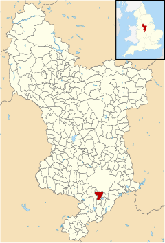
 Barrow upon Trent parish highlighted within Derbyshire | |
| Population | 558 (2011) |
| OS grid reference | SK353285 |
| Civil parish |
|
| District | |
| Shire county | |
| Region | |
| Country | England |
| Sovereign state | United Kingdom |
| Post town | DERBY |
| Postcode district | DE73 |
| Dialling code | 01332 |
| Police | Derbyshire |
| Fire | Derbyshire |
| Ambulance | East Midlands |
Barrow upon Trent is a village and civil parish in the South Derbyshire district of Derbyshire, England with a business park planned for the outskirts of the village. The village is south of Derby, and between the River Trent (to the south) and the Trent and Mersey Canal (to the north). According to the 2001 census the parish had a population of 546,[1] increasing to 558 at the 2011 Census.[2] Nearby places are Sinfin, Ingleby, Arleston, and Swarkestone.

One of the earliest mentions of this place is in the Domesday book where it is listed amongst the lands given to Henry de Ferrers[3] by the King. The land included 8 acres (32,000 m2) of ground space and there were four oxen. Some of the land was described as "waste" but the value was put at two shillings.
The parish council owns an attractive row of ten Grade II listed cottages, known as "The Row". These are rented to people with village connections.[1] It also owns "The Pinfold", a small walled area originally used for holding stray cattle. The village is home to a Tarmac quarry.
Famous people
editBarrow-Upon-Trent was home to the writer Anne Mozley[4] and the artist George Turner (1841–1910) who moved here from Cromford. Turner went on to train his son, William Lakin Turner, along with David Payne in the village.
Facilities
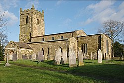
editIn the parish there are a number of facilities: village hall, public house, youth group, preschool playgroup (2 years and above), Sale and Davys C of E Primary School, St Wilfrid's church (developed by the Knights Hospitallers) and a children's play park as well, as a larger park with both a full size and a smaller size football pitch. There is no shop or post office.
Transport
editThe main road, the A5132 has bypassed the village, if the houses on Swarkestone Road are to be excluded, since 1969. There are bus services to Melbourne and Derby, but only on weekdays.
See also
editReferences
edit- ^ a b Parish council site accessed 20 March 2013
- ^ "Civil Parish population 2011". Neighbourhood Statistics. Office for National Statistics. Archived from the original on 15 September 2016. Retrieved 19 March 2016.
- ^ Domesday Book: A Complete Translation. London: Penguin, 2003. p. 748 ISBN 0-14-143994-7
- ^ Ellen Jordan, ‘Mozley, Anne (1809–1891)’, Oxford Dictionary of National Biography, Oxford University Press, 2004 accessed 17 Nov 2014