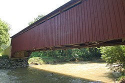
The Baumgardener's Covered Bridge is a covered bridge that spans Pequea Creek in Lancaster County, Pennsylvania, United States. A county-owned and maintained bridge, its official designation is the Pequea #10 Bridge. Note: The mill was constructed in 1800.
Baumgardener's Covered Bridge | |
|---|---|
 | |
| Coordinates | 39°55′50″N 76°17′42″W / 39.93056°N 76.29500°W |
| Carries | Township 427 |
| Crosses | Pequea Creek |
| Official name | Pequea #10 Bridge |
| Maintained by | Lancaster County |
| WGCB Number | 38-36-25 |
| Characteristics | |
| Design | Burr Arch Truss Bridge |
| Total length | 120 ft (37 m) |
| Width | 4.3 m (14 ft)[1] |
| Height | 11.5 ft (3.5 m) |
| History | |
| Constructed by | Davis Kitch |
| Construction end | 1860 |
| Rebuilt | 1987 |
Baumgardner's Mill Covered Bridge | |
| MPS | Covered Bridges of Lancaster County TR |
| NRHP reference No. | 80003541[2] |
| Added to NRHP | December 11, 1980 |
| Location | |
 | |
The bridge has a single span, wooden, double Burr arch trusses design with the addition of steel hanger rods. The deck is made from oak planks.[3] It is painted red, the traditional color of Lancaster County covered bridges, on both the inside and outside. Both approaches to the bridge are painted in the traditional white color.
The bridge is located approximately 0.5 miles (0.80 km) north of Frogtown Road on Covered Bridge Road just to the east of Pennsylvania Route 324 in Martic Township.[4] The bridge's WGCB Number is 38-36-25.[5] It was listed on the National Register of Historic Places on December 11, 1980.
History
editThe Baumgardener's Covered Bridge was built in 1860 by Davis Kitch at a cost of $1,284. In 1987 the bridge was restored after it was damaged in a flood the previous year. During this restoration process, which cost $200,000, the bridge was raised by 4 feet (1.2 m) and lengthened by 9 feet (2.7 m) to protect it from damage in potential future flooding.[4]
Gallery
edit-
Baumgardener's Covered Bridge from the air #1
-
Baumgardener's Covered Bridge from the air #2
-
Baumgardener's Covered Bridge from the air #3
See also
editReferences
edit- ^ Federal Highway Administration (2008). "Place Name: Pequea (Township of), Pennsylvania NBI Structure Number: 367228042515100; Facility Carried: T-427, Covered Bridge Rd; Feature Intersected: Peqeua Creek". Nationalbridges.com (Alexander Svirsky). Retrieved November 20, 2008.[permanent dead link] Note: this is a formatted scrape of the 2006 official website, which can be found here for Pennsylvania: "PA06.txt". Federal Highway Administration. 2006. Retrieved November 20, 2008.
- ^ "National Register Information System". National Register of Historic Places. National Park Service. July 9, 2010.
- ^ "Baumgardener's Covered Bridge". County of Lancaster, Pennsylvania. October 20, 2001. Archived from the original on September 27, 2007. Retrieved August 7, 2006.
- ^ a b "Baumgardner's Covered Bridge". Pennsylvania Dutch Convention & Visitors Bureau. 2006. Archived from the original on March 17, 2006. Retrieved July 7, 2006.
- ^ McCain, Roger A. "Baumgardner's Mill Bridge". A Guide to Old Covered Bridges of Southeastern Pennsylvania and nearby areas. Archived from the original on 7 September 2006. Retrieved August 3, 2006.