Dawson is a township located in Rainy River District in Northwestern Ontario, Canada. The township is located at the mouth of the Rainy River where it flows into Lake of the Woods.
Dawson | |
|---|---|
| Township of Dawson | |
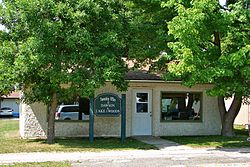
 Township office of Dawson in Rainy River | |
| Coordinates: 48°45′N 94°29′W / 48.750°N 94.483°W | |
| Country | Canada |
| Province | Ontario |
| District | Rainy River |
| Formed | 1 January 1997 |
| Government | |
| • Mayor | Douglas Hartnell |
| • Federal riding | Thunder Bay—Rainy River |
| • Prov. riding | Kenora—Rainy River |
| Area | |
| • Land | 339.5 km2 (131.1 sq mi) |
| Elevation | 335 m (1,099 ft) |
| Population (2016)[1] | |
• Total | 468 |
| • Density | 1.4/km2 (4/sq mi) |
| Time zone | UTC-6 (CST) |
| • Summer (DST) | UTC-5 (CDT) |
| Postal Code FSA | P0W 1L0 |
| Area code | 807 |
The township was formed on 1 January 1997, when the former incorporated townships of Atwood, Blue, Dilke, and Worthington were amalgamated.[3]
The name was chosen in order to recognize the historical Dawson trail which was the main route of settlers moving from the east to the western part of Canada.[4]
Communities
editThe primary communities in the township are Blue, McGinnis Creek, Pinewood and Sleeman.
-
Pinewood
Demographics
editIn the 2021 Census of Population conducted by Statistics Canada, Dawson had a population of 399 living in 190 of its 274 total private dwellings, a change of -14.7% from its 2016 population of 468. With a land area of 343.42 km2 (132.60 sq mi), it had a population density of 1.2/km2 (3.0/sq mi) in 2021.[5]
| 2021 | 2016 | 2011 | |
|---|---|---|---|
| Population | 399 (-14.7% from 2016) | 468 (-16.9% from 2011) | 563 (-9.2% from 2006) |
| Land area | 343.42 km2 (132.60 sq mi) | 339.5 km2 (131.1 sq mi) | 338.35 km2 (130.64 sq mi) |
| Population density | 1.2/km2 (3.1/sq mi) | 1.4/km2 (3.6/sq mi) | 1.7/km2 (4.4/sq mi) |
| Median age | 56.4 (M: 57.6, F: 53.6) | 54.5 (M: 54.9, F: 53.5) | 47.8 (M: 49.1, F: 46.2) |
| Private dwellings | 274 (total) 190 (occupied) | 292 (total) | 307 (total) |
| Median household income | $75,000 | $61,312 |
| Year | Pop. | ±% |
|---|---|---|
| 1996 | 631 | — |
| 2001 | 613 | −2.9% |
| 2006 | 620 | +1.1% |
| 2011 | 563 | −9.2% |
| 2016 | 468 | −16.9% |
| [11][1] | ||
Climate
edit| Climate data for Sleeman | |||||||||||||
|---|---|---|---|---|---|---|---|---|---|---|---|---|---|
| Month | Jan | Feb | Mar | Apr | May | Jun | Jul | Aug | Sep | Oct | Nov | Dec | Year |
| Record high °C (°F) | 7 (45) |
11 (52) |
16.5 (61.7) |
31.5 (88.7) |
32.5 (90.5) |
33.5 (92.3) |
35 (95) |
34.5 (94.1) |
34.4 (93.9) |
26.7 (80.1) |
22.2 (72.0) |
9 (48) |
35 (95) |
| Mean daily maximum °C (°F) | −11.4 (11.5) |
−7 (19) |
0.3 (32.5) |
10.5 (50.9) |
18.8 (65.8) |
22.3 (72.1) |
25 (77) |
23.4 (74.1) |
17.3 (63.1) |
10.5 (50.9) |
−0.2 (31.6) |
−8.9 (16.0) |
8.4 (47.1) |
| Daily mean °C (°F) | −17.2 (1.0) |
−13.2 (8.2) |
−5.6 (21.9) |
4.1 (39.4) |
11.8 (53.2) |
16.2 (61.2) |
19 (66) |
17.4 (63.3) |
11.8 (53.2) |
5.7 (42.3) |
−4.1 (24.6) |
−14 (7) |
2.7 (36.9) |
| Mean daily minimum °C (°F) | −22.9 (−9.2) |
−19.3 (−2.7) |
−11.4 (11.5) |
−2.2 (28.0) |
4.8 (40.6) |
9.9 (49.8) |
12.9 (55.2) |
11.4 (52.5) |
6.3 (43.3) |
0.8 (33.4) |
−8 (18) |
−19.1 (−2.4) |
−3.1 (26.4) |
| Record low °C (°F) | −44 (−47) |
−41 (−42) |
−37.5 (−35.5) |
−27.8 (−18.0) |
−8 (18) |
−2 (28) |
1.1 (34.0) |
−1.7 (28.9) |
−6 (21) |
−17 (1) |
−39 (−38) |
−43 (−45) |
−44 (−47) |
| Average precipitation mm (inches) | 27.9 (1.10) |
21.6 (0.85) |
30.1 (1.19) |
37.9 (1.49) |
60.4 (2.38) |
107.5 (4.23) |
86.4 (3.40) |
90.5 (3.56) |
69.3 (2.73) |
57.7 (2.27) |
37.2 (1.46) |
23.5 (0.93) |
650 (25.6) |
| Source: Environment Canada[2] | |||||||||||||
See also
editReferences
edit- ^ a b c "Census Profile, 2016 Census: Dawson, Township". Statistics Canada. 8 February 2017. Retrieved 2 July 2019.
- ^ a b Environment Canada – Canadian Climate Normals 1971–2000, accessed 2011-05-05
- ^ "Dawson Township – Rainy River District, Ontario". Retrieved 1 October 2024.
- ^ "Dawson Township – Rainy River District, Ontario". Retrieved 1 October 2024.
- ^ "Population and dwelling counts: Canada, provinces and territories, census divisions and census subdivisions (municipalities), Ontario". Statistics Canada. 9 February 2022. Retrieved 2 April 2022.
- ^ "2021 Community Profiles". 2021 Canadian census. Statistics Canada. 4 February 2022. Retrieved 19 October 2023.
- ^ "2016 Community Profiles". 2016 Canadian census. Statistics Canada. 12 August 2021. Retrieved 2 July 2019.
- ^ "2011 Community Profiles". 2011 Canadian census. Statistics Canada. 21 March 2019. Retrieved 30 March 2012.
- ^ "2006 Community Profiles". 2006 Canadian census. Statistics Canada. 20 August 2019.
- ^ "2001 Community Profiles". 2001 Canadian census. Statistics Canada. 18 July 2021.
- ^ Statistics Canada: 2001, 2006, 2011 census
