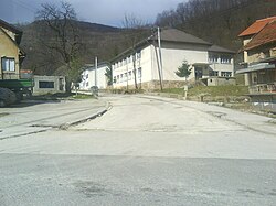
Bradina (Serbian Cyrillic: Брадина) is a village in the municipality of Konjic in Herzegovina, Federation of Bosnia and Herzegovina, Bosnia and Herzegovina.
Bradina
Брадина | |
|---|---|
Village | |
 | |
| Coordinates: 43°44′41″N 18°01′08″E / 43.74472°N 18.01889°E | |
| Country | |
| Entity | Federation of Bosnia and Herzegovina |
| Canton | |
| Municipality | |
| Area | |
• Total | 7.59 sq mi (19.67 km2) |
| Population (2013) | |
• Total | 72 |
| • Density | 9.5/sq mi (3.7/km2) |
| Time zone | UTC+1 (CET) |
| • Summer (DST) | UTC+2 (CEST) |
History
editIn May 1992, forty-eight Bosnian Serb civilians were killed in Bradina by the Army of Bosnia and Herzegovina and the Croatian Defence Council.[1]
Population
edit| Census year | 1971 | 1981 | 1991 | 2013 [2] |
|---|---|---|---|---|
| Serbs | 724 (87.65%) | 620 (88.57%) | 603 (90.67%) | 3 (4.2%) |
| Croats | 64 (7.74%) | 44 (6.28%) | 32 (4.81%) | 3 (4.2%) |
| Bosniaks | 36 (4.35%) | 14 (2.00%) | 16 (2.40%) | 66 (91.7%) |
| Yugoslavs | 0 | 22 (3.14%) | 12 (1.80%) | |
| others | 2 (0.24%) | 0 | 2 (0.30%) | |
| Total | 826 | 700 | 665 | 72 |
Notable people
edit- Ante Pavelić, founder of the Croatian nationalist Ustaše movement and leader of the Independent State of Croatia during World War II[3]
References
edit- ^ Kočan, Faris (2023). Identity, Ontological Security and Europeanisation in Republika Srpska. New York City: Springer. p. 116. ISBN 978-3-0314-6169-9.
- ^ "Naseljena Mjesta 1991/2013" (in Bosnian). Statistical Office of Bosnia and Herzegovina. Retrieved October 2, 2021.
- ^ Tanner, Marcus (2001). Croatia: A Nation Forged in War. New Haven, Connecticut: Yale University Press. pp. 124, 154. ISBN 978-0-300-09125-0.
Sources
edit- Nacionalni sastav stanovništva - Rezultati za Republiku po opštinama i naseljenim mjestima 1991., statistički bilten br. 234, Izdanje Državnog zavoda za statistiku Republike Bosne i Hercegovine, Sarajevo. ("Ethnic composition of the population - results, by municipalities and settlements in 1991, Statistical Bulletin no. 234, Issue of the Central Bureau of Statistics of Bosnia and Herzegovina, Sarajevo.
- List of the local communities
