This article needs additional citations for verification. (April 2015) |
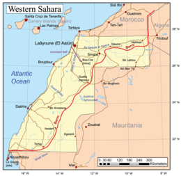
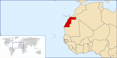
Western Sahara is a territory in Northern Africa, bordered by the North Atlantic Ocean, Morocco proper, Algeria (Tindouf region), and Mauritania. Geographic coordinates: 24°30′N 13°00′W / 24.500°N 13.000°W
  | |
| Continent | Africa |
|---|---|
| Region | North Africa |
| Coordinates | 24°30′N 13°00′W / 24.500°N 13.000°W |
| Area | Ranked 78th |
| • Total | 266,000 km2 (103,000 sq mi) |
| Coastline | 1,110 km (690 mi) |
| Borders |
|
| Highest point | unnamed elevation: 701 metres (2,300 ft) |
| Lowest point | Sebjet Tah, −55 metres (−180 ft) [citation needed] |


Size of Western Sahara
editThe size of Western Sahara, a region located in North Africa, is a critical aspect of its geopolitical and environmental profile. The territory’s vastness impacts its resource distribution, strategic importance, and the ongoing conflict over its sovereignty. Western Sahara is a significant area of study for its complex history and its role in regional and global geopolitics.
Area
editWestern Sahara encompasses approximately 266,000 square kilometers (102,703 square miles), which places it among the larger regions of Africa. This measurement provides a broad perspective on the land’s scale, revealing its comparative size to other nations and regions. For instance, Western Sahara is slightly larger than the United Kingdom but smaller than some of Africa’s largest countries, such as Algeria and Sudan.[2] The size of Western Sahara is not merely a numerical fact; it is intrinsically linked to its physical geography and the strategic interests it holds for various stakeholders. The arid climate and extensive desert areas define much of its landscape, influencing the lifestyle of its inhabitants and the approaches taken by both local and international actors in addressing the territory's status and development.[3]
The region’s area also affects logistical considerations, such as the management of natural resources and the implementation of infrastructure projects. Its size presents both challenges and opportunities for resource exploration, environmental management, and territorial administration. Despite its vastness, much of Western Sahara remains sparsely populated, with the majority of its residents living in a few concentrated areas. This uneven distribution of population relative to the land area plays a significant role in the political and humanitarian issues faced by the region.
Geographic Context
editWestern Sahara's geographic location is pivotal in understanding its significance. Situated in the northwest corner of Africa, it is bordered by Morocco to the north and east, Algeria to the northeast, Mauritania to the southeast, and the Atlantic Ocean to the west.[4] This strategic position places it at the intersection of several historical and cultural exchange routes, which have influenced its development and the broader regional dynamics.
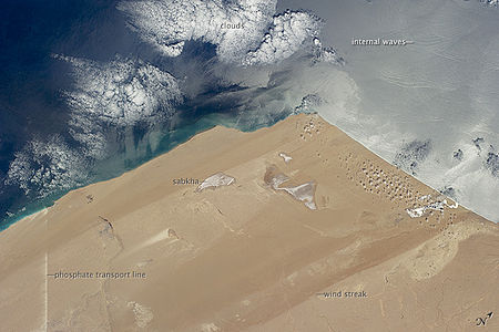
The landscape of Western Sahara is dominated by desert terrain, with features such as sand dunes, rocky plateaus, and sparse vegetation. The coastal areas along the Atlantic Ocean provide a contrast to the inland desert, offering a more temperate climate and supporting limited but important marine and coastal ecosystems.[5] The terrain’s aridity and the lack of significant water resources have shaped the settlement patterns and economic activities within the region. Historical trade routes and migratory paths that traverse Western Sahara are a testament to its historical significance in connecting different parts of Africa and beyond.
Additionally, the desert environment poses unique challenges for infrastructure development and resource management. The region's natural resources, including phosphate deposits and potential offshore oil reserves, add another layer of complexity to the geopolitical stakes associated with its size and geography.[6]
Land
editTerrain
editThe terrain is mostly low, flat desert with large areas of rocky or sandy surfaces rising to small mountains in south and northeast.
Elevation extremes:
- Lowest point: Sebjet Tah, −55 metres (−180 ft), a depression in the northwest part of Western Sahara straddling the Morocco border
- Highest point: Unnamed elevation, 701 metres (2,300 ft), east of Awsard (Aousserd)[7]
Natural resources
editPhosphates, iron ore, and fishing resources on Atlantic Ocean coast
Land use
editArable land: 0.02%
- Permanent crops: 0%
- Other: 99.98% (2005)
Irrigated land: N/A
Natural hazards
editHot, dry, dust/sand-laden sirocco wind can occur during winter and spring; widespread harmattan haze exists 60% of time, often severely restricting visibility. Flash flooding occurs during spring months.
Environment
editClimate
editWestern Sahara has a hot desert climate (Köppen climate classification BWh). Annual average rainfall is below 50 millimetres (2.0 in) everywhere. Along the Atlantic coast, average temperatures, both high and low, are constant and very moderated throughout the year because cool offshore ocean currents considerably cool off the climate, especially during the day. However, summertime is long and extremely hot and wintertime is short and very warm to truly hot further in the interior, where cooling marine influences aren't felt anymore. Average high temperatures exceed 40 °C (104 °F) in summer during a prolonged period of time but can reach as high as 50 °C (122 °F) or even more in places such as Smara, Tichla, Bir Gandus, Bir Anzarane, Aghouinite, Aousserd and others. Average high temperatures exceed 20 °C (68 °F) in winter but average low temperatures can drop to 7 °C (45 °F) in some places. The sky is usually clear and bright throughout the year and sunny weather is the norm.
| Climate data for Laayoune (1981-2010 normals) | |||||||||||||
|---|---|---|---|---|---|---|---|---|---|---|---|---|---|
| Month | Jan | Feb | Mar | Apr | May | Jun | Jul | Aug | Sep | Oct | Nov | Dec | Year |
| Mean daily maximum °C (°F) | 22.2 (72.0) |
22.7 (72.9) |
24.5 (76.1) |
23.9 (75.0) |
25.6 (78.1) |
27.4 (81.3) |
29.5 (85.1) |
30.4 (86.7) |
30.0 (86.0) |
28.6 (83.5) |
26.0 (78.8) |
23.2 (73.8) |
26.2 (79.2) |
| Daily mean °C (°F) | 16.9 (62.4) |
17.6 (63.7) |
19.2 (66.6) |
19.2 (66.6) |
20.7 (69.3) |
22.5 (72.5) |
24.5 (76.1) |
25.2 (77.4) |
24.7 (76.5) |
23.3 (73.9) |
20.8 (69.4) |
18.0 (64.4) |
21.1 (70.0) |
| Mean daily minimum °C (°F) | 11.6 (52.9) |
12.5 (54.5) |
13.9 (57.0) |
14.5 (58.1) |
15.8 (60.4) |
17.7 (63.9) |
19.4 (66.9) |
20.0 (68.0) |
19.4 (66.9) |
18.0 (64.4) |
15.6 (60.1) |
12.8 (55.0) |
15.9 (60.6) |
| Average precipitation mm (inches) | 11.1 (0.44) |
11.1 (0.44) |
5.4 (0.21) |
1.1 (0.04) |
0.5 (0.02) |
0.0 (0.0) |
0.1 (0.00) |
0.5 (0.02) |
1.5 (0.06) |
3.0 (0.12) |
9.8 (0.39) |
13.3 (0.52) |
57.4 (2.26) |
| Mean monthly sunshine hours | 239.1 | 234.7 | 281.4 | 296.5 | 326.5 | 308.9 | 290.3 | 286.9 | 260.1 | 266.1 | 243.9 | 229.8 | 3,264.2 |
| Source: NOAA[8] | |||||||||||||
| Climate data for Dakhla, Western Sahara | |||||||||||||
|---|---|---|---|---|---|---|---|---|---|---|---|---|---|
| Month | Jan | Feb | Mar | Apr | May | Jun | Jul | Aug | Sep | Oct | Nov | Dec | Year |
| Record high °C (°F) | 33.0 (91.4) |
33.9 (93.0) |
37.0 (98.6) |
37.2 (99.0) |
42.0 (107.6) |
36.0 (96.8) |
38.9 (102.0) |
39.0 (102.2) |
41.8 (107.2) |
39.6 (103.3) |
37.0 (98.6) |
31.6 (88.9) |
42.0 (107.6) |
| Mean daily maximum °C (°F) | 20.9 (69.6) |
22.7 (72.9) |
23.7 (74.7) |
23.3 (73.9) |
24.0 (75.2) |
24.8 (76.6) |
25.7 (78.3) |
26.5 (79.7) |
27.4 (81.3) |
26.6 (79.9) |
25.1 (77.2) |
22.5 (72.5) |
24.4 (75.9) |
| Daily mean °C (°F) | 18.1 (64.6) |
18.4 (65.1) |
20.0 (68.0) |
19.2 (66.6) |
19.9 (67.8) |
20.7 (69.3) |
21.9 (71.4) |
22.7 (72.9) |
23.0 (73.4) |
22.6 (72.7) |
20.8 (69.4) |
18.7 (65.7) |
20.5 (68.9) |
| Mean daily minimum °C (°F) | 13.3 (55.9) |
13.8 (56.8) |
14.7 (58.5) |
14.9 (58.8) |
15.8 (60.4) |
16.7 (62.1) |
17.5 (63.5) |
18.3 (64.9) |
18.8 (65.8) |
18.0 (64.4) |
16.6 (61.9) |
14.5 (58.1) |
16.1 (61.0) |
| Record low °C (°F) | 8.5 (47.3) |
8.8 (47.8) |
10.0 (50.0) |
10.0 (50.0) |
11.0 (51.8) |
11.1 (52.0) |
10.0 (50.0) |
13.0 (55.4) |
12.0 (53.6) |
9.0 (48.2) |
8.0 (46.4) |
7.2 (45.0) |
7.2 (45.0) |
| Average precipitation mm (inches) | 2.3 (0.09) |
2.8 (0.11) |
1.0 (0.04) |
0.0 (0.0) |
0.4 (0.02) |
0.0 (0.0) |
1.4 (0.06) |
2.1 (0.08) |
10.9 (0.43) |
6.3 (0.25) |
2.6 (0.10) |
9.8 (0.39) |
39.7 (1.56) |
| Average precipitation days (≥ 0.1 mm) | 0.9 | 1.0 | 0.6 | 0.5 | 0.7 | 0.2 | 0.3 | 0.8 | 1.8 | 0.9 | 1.3 | 1.6 | 10.7 |
| Average relative humidity (%) | 70 | 77 | 75 | 75 | 78 | 79 | 81 | 82 | 80 | 77 | 76 | 73 | 77 |
| Mean monthly sunshine hours | 254.2 | 245.8 | 275.9 | 276.0 | 306.9 | 291.0 | 266.6 | 272.8 | 249.0 | 254.2 | 240.0 | 241.8 | 3,174.2 |
| Mean daily sunshine hours | 8.2 | 8.7 | 8.9 | 9.2 | 9.9 | 9.7 | 8.6 | 8.8 | 8.3 | 8.2 | 8.0 | 7.8 | 8.7 |
| Source: Deutscher Wetterdienst[9] | |||||||||||||
Current issues
editThis section needs expansion. You can help by adding to it. (May 2022) |
Sparse water and lack of arable land.
Extreme points
editThis is a list of the extreme points of Western Sahara, the points that are farther north, south, east or west than any other location.
- Northernmost points – the border with Morocco*
- Easternmost points – the northern section of the border with Mauritania/Algeria**
- Southernmost point – the southern tip of Ras Nouadhibou (Cabo Blanco/Cap Blanc)
- Westernmost point – Cape Dubouchage on Ras Nouadhibou
- Note: Western Sahara does not have a northernmost point, the border being formed by a circle of latitude
- Note: Western Sahara does not have an easternmost point, the border being formed by a meridian
References
edit- ^ Desert Coast—Morocco, Western Sahara at NASA Earth Observatory
- ^ CIA World Factbook: Western Sahara
- ^ Smith, B. (2010). Geopolitical Dimensions of Western Sahara. Geographical Review, 24(3), 345-356.
- ^ Western Sahara - Encyclopaedia Britannica
- ^ Parker, C. (2015). Desert Landscapes of Western Sahara: An Environmental Overview. Desert Studies Journal, 31(2), 210-229.
- ^ Jones, M. (2017). Economic Resources and Environmental Challenges in Western Sahara. African Geopolitics Review, 29(4), 400-415.
- ^ Western Sahara High Point,Peakbagger.com
- ^ "WMO_Normals_ASCII_60033". National Oceanic and Atmospheric Administration. Retrieved August 4, 2021.
- ^ "Klimatafel von Dakhla (Villa Cisneros) / Westsahara (Dem. Arab. Rep. Sahara)" (PDF). Baseline climate means (1961-1990) from stations all over the world (in German). Deutscher Wetterdienst. Retrieved 6 November 2018.