This article needs additional citations for verification. (June 2017) |
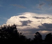
A pileus (/ˈpaɪliəs/; Latin for 'cap'), also called scarf cloud or cap cloud, is a small, horizontal, lenticular cloud appearing above a cumulus or cumulonimbus cloud. Pileus clouds are often short-lived, appearing for typically only a few minutes,[1] with the main cloud beneath them rising through convection to absorb them. Furthermore, the clouds are typically formed by drier air with a higher lifting condensation level, which often prevents vertical growth and leads to the smooth horizontal cap shape that the cloud is named for.[2]


They are formed by strong updraft at lower altitudes, acting upon moist air above, causing the air to cool to its dew point as it rises.[3][4] As such, they are usually indicators of severe weather, and a pileus found atop a cumulus cloud often foreshadows transformation into a cumulonimbus cloud, as it indicates a strong updraft within the cloud.[3][5]
Pilei can also form above mountains, ash clouds, and pyrocumulus clouds from erupting volcanoes.[6] Pilei form above some mushroom clouds of high-yield nuclear detonations.[7]
Appearance
editThough the pileus cloud does not tend to grow vertically, sometimes several pileus clouds are observed above each other.[8] The bright iridescent colors seen in pileus are sunlight diffracted in water vapor. Iridescent colors are strongest when the diffracting droplets are small and similar in size. The newly formed pileus droplet all of similar provenance are ideal for iridescence.[9]
Variants
editWhen sheet of altostratus cloud is seen lower down and skirting a cumulonimbus cloud, it is classified as a velum cloud.[10]
Forecast
editPileus clouds indicate the parent cloud is growing rapidly, has plenty of moisture, and is highly unstable. This means the parent cloud could quickly grow to become a cumulonimbus cloud and continue to grow into a cumulonimbus incus cloud.[3]
See also
editReferences
edit- ^ "UBC ATSC 113 - Pileus clouds". www.eoas.ubc.ca. Retrieved 2023-11-28.
- ^ "Pileus Clouds: smooth capping clouds". ww2010.atmos.uiuc.edu. Retrieved 2023-11-28.
- ^ a b c Ulrike, Lohmann. An Introduction to Clouds: From the Microscale to Climate. Lüönd, Felix; Mahrt, Fabian. Cambridge. p. 288. ISBN 9781139087513. OCLC 953455396.
- ^ Garrett, T. J.; Dean-Day, J.; Liu, C.; Barnett, B.; Mace, G.; Baumgardner, D.; Webster, C.; Bui, T.; Read, W.; Minnis, P. (19 April 2006). "Convective formation of pileus cloud near the tropopause". Atmospheric Chemistry and Physics. 6 (5): 1185–1200. Bibcode:2006ACP.....6.1185G. doi:10.5194/acp-6-1185-2006. hdl:2060/20080015842.
- ^ "Facebook". www.facebook.com. Retrieved 2023-12-11.
- ^ Hamblyn, Richard (2017-05-15). Clouds. London. ISBN 9781780237701. OCLC 1000297560.
{{cite book}}: CS1 maint: location missing publisher (link) - ^ Holzmann, B. G.; Cumberledge, A. A. (October 1946). "Weather and The Atomic Bomb Tests at Bikini (II)". Bulletin of the American Meteorological Society. 27 (8): 435–437. Bibcode:1946BAMS...27..435H. doi:10.1175/1520-0477-27.8.435.
- ^ "Pileus - AMS Glossary". glossary.ametsoc.org. Retrieved 2019-01-25.
- ^ "Iridescent Pileus". Atmospheric Optics. Retrieved 2019-01-25.
- ^ "Velum". Meteorological glossary. American Meteorological Society. Retrieved May 2, 2014.
External links
edit