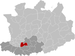
Duffel (Dutch pronunciation: [ˈdʏfəl] ) is a municipality in the Belgian province of Antwerp.
Duffel | |
|---|---|
 Duffel Town Hall | |
| Coordinates: 51°06′N 04°31′E / 51.100°N 4.517°E | |
| Country | |
| Community | Flemish Community |
| Region | Flemish Region |
| Province | Antwerp |
| Arrondissement | Mechelen |
| Government | |
| • Mayor | Sofie Joosen (N-VA) |
| • Governing party/ies | N-VA, CD&V |
| Area | |
• Total | 22.6 km2 (8.7 sq mi) |
| Population (2020-01-01)[1] | |
• Total | 17,664 |
| • Density | 780/km2 (2,000/sq mi) |
| Postal codes | 2570 |
| NIS code | 12009 |
| Area codes | 015, 03 |
| Website | www.duffel.be |
The municipality comprises the town of Duffel proper. On 1 January 2020, Duffel had a total population of 17,664. The total area is 22.71 km2 which gives a population density of 778 inhabitants per km2.
The area is the eponym of a coarse woolen cloth, manufactured in this area from the 11th century, mainly used to make blankets, outdoor (army) coats, and tote bags. Duffel became a household name during and after World War II in the meaning of a coat designed with toggle-and-loop fastening and roomy hood.[2]
The etymology of Duffel is from "dubro" and "locus", from the Gaulish dubrum, dubron – "water".
In 1836, the Duffel railway station opened on the Brussels-North to Antwerp railway line.[3]
Duffel cloth
editThe town gives its name to a type of heavy woolen cloth generally used to make blankets and overcoats, especially for the armed forces, and a type of luggage.[4] In the Middle Ages, an important part of the region's industry was the manufacturing of Flemish laken (a broadcloth), while the cloth produced in Duffel was a thicker variation. The manufacturing process was brought to England by Flemish emigrants in the 1500s.[5] The name for the cloth was so well-known that a type of overcoat made from the cloth and manufactured in England got the name Duffel coat.[6][7]
Notable natives
edit- Jan Van Der Roost, composer
- Kevin De Weert, cyclist
- Andreas Pereira, footballer
- Metejoor, singer
- Cornelis Kiliaan (1528–1607), lexicographer and poet
- Hendrik Hondius I (1573–1650), engraver, cartographer and publisher
- Rocky Bushiri, footballer for Hibernian FC
- Gaëtan De Knyff, racing driver
Climate
edit| Climate data for Duffel (1991−2020 normals) | |||||||||||||
|---|---|---|---|---|---|---|---|---|---|---|---|---|---|
| Month | Jan | Feb | Mar | Apr | May | Jun | Jul | Aug | Sep | Oct | Nov | Dec | Year |
| Mean daily maximum °C (°F) | 6.7 (44.1) |
7.7 (45.9) |
11.2 (52.2) |
15.5 (59.9) |
19.0 (66.2) |
21.8 (71.2) |
23.9 (75.0) |
23.7 (74.7) |
20.1 (68.2) |
15.4 (59.7) |
10.4 (50.7) |
7.1 (44.8) |
15.2 (59.4) |
| Daily mean °C (°F) | 4.0 (39.2) |
4.4 (39.9) |
7.1 (44.8) |
10.3 (50.5) |
14.1 (57.4) |
17.0 (62.6) |
19.1 (66.4) |
18.7 (65.7) |
15.4 (59.7) |
11.5 (52.7) |
7.4 (45.3) |
4.5 (40.1) |
11.1 (52.0) |
| Mean daily minimum °C (°F) | 1.3 (34.3) |
1.1 (34.0) |
2.9 (37.2) |
5.3 (41.5) |
9.2 (48.6) |
12.2 (54.0) |
14.3 (57.7) |
13.8 (56.8) |
10.7 (51.3) |
7.5 (45.5) |
4.3 (39.7) |
1.9 (35.4) |
7.0 (44.7) |
| Average precipitation mm (inches) | 68.0 (2.68) |
60.3 (2.37) |
54.1 (2.13) |
40.8 (1.61) |
55.4 (2.18) |
72.6 (2.86) |
76.3 (3.00) |
81.6 (3.21) |
69.3 (2.73) |
64.4 (2.54) |
74.3 (2.93) |
84.2 (3.31) |
801.3 (31.55) |
| Average precipitation days (≥ 1.0 mm) | 11.9 | 11.1 | 10.4 | 8.5 | 9.5 | 9.8 | 10.2 | 10.1 | 9.6 | 10.6 | 12.1 | 13.4 | 127.2 |
| Mean monthly sunshine hours | 61 | 77 | 134 | 188 | 218 | 218 | 223 | 210 | 163 | 117 | 66 | 51 | 1,726 |
| Source: Royal Meteorological Institute[8] | |||||||||||||
Gallery
edit-
Fort van Duffel
-
Onze-Lieve-Vrouw van de Goede Wil church
-
Betlehem Convent
-
Pub in Duffel
See also
editReferences
edit- ^ "Bevolking per gemeente op 1 januari 2020". Statbel.
- ^ "History of the Duffel Coat". Retrieved 10 September 2022.
- ^ "L. 25 : Brussel-Noord - Antwerpen". Belgische Spoorlijnen. Retrieved 11 May 2022.
- ^ "Duffel". Online Etymology Dictionary. Retrieved April 27, 2011.
- ^ Jarvis, Joanne (January 2009). "Braintree is reborn". Essex Life. Archant.
- ^ "The History of the Duffel Coat". Retrieved 10 September 2022.
- ^ "Duffel Coat History". Retrieved 12 September 2022.
- ^ "Luchttemperatuur en neerslag Referentieperiode: 1991-2020" (PDF) (in Dutch). Royal Meteorological Institute. Retrieved August 10, 2022.
External links
edit- Media related to Duffel at Wikimedia Commons
- Official website


