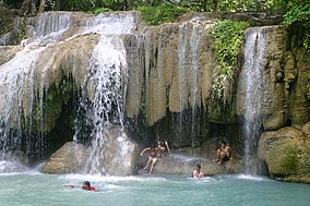
Erawan National Park (Thai: อุทยานแห่งชาติเอราวัณ) is a protected area in Western Thailand, in the Tenasserim Hills of Kanchanaburi Province. Founded in 1975, it was the 12th national park of Thailand.[citation needed]
| Erawan National Park | |
|---|---|
 Erawan Waterfall | |
 | |
| Location | Kanchanaburi Province, Thailand |
| Nearest city | Kanchanaburi |
| Coordinates | 14°23′N 99°07′E / 14.383°N 99.117°E |
| Area | 550 km2 (210 sq mi) |
| Established | 1975 |
| Visitors | 650,852 (in 2019) |
| Governing body | Department of National Park, Wildlife and Plant Conservation (DNP) |
History
editThe establishment of the national park was declared in the Royal Thai Government Gazette on 19 June 1975 and came into effect the following day.[1] This park area was further modified in 1995.[2]
The park covers an area of 343,750 rai (550 km2; 212 sq mi)[3] in Sai Yok, Tha Sao and Lum Sum subdistricts in Sai Yok District; Nong Pet and Tha Kradan subdistricts in Si Sawat District, and Chong Sadao Subdistrict in Mueang Kanchanaburi District.[1]
Features
editThe major attraction of the park is Erawan Falls, a waterfall named after Erawan, the three-headed white elephant of Hindu mythology. The seven-tiered falls are said to resemble Erawan.[4] There are four caves in the park: Mi, Rua, Wang Badan, and Phrathat.[5] Rising northeast of the waterfall area there is a breast-shaped hill named Khao Nom Nang.[6]
Flora
editMixed deciduous forest accounts for 81% of the national park area.[7] Deciduous dipterocarp forest accounts for 1.68% of the national park area. Dry evergreen forests account for 14.35% of the national park area.[citation needed]
Fauna
editMammals:
Birds:
Reptiles:
Amphibians:
Aquatic Animals:
See also
editReferences
edit- ^ a b "พระราชกฤษฎีกากำหนดบริเวณที่ดินป่าเขาสลอบ ในท้องที่ตำบลไทรโยค ตำบลท่าเสา ตำบลลุ่มสุ่ม อำเภอไทรโยค ตำบลหนองเป็ด ตำบลท่ากระดาน อำเภอศรีสวัสดิ์ และตำบลช่องสะเดา อำเภอเมืองกาญจนบุรี จังหวัดกาญจนบุรี ให้เป็นอุทยานแห่งชาติ พ.ศ. ๒๕๑๘" [Royal decree declaring the area of Khao Salop Forest in the localities of Tambon Sai Yok, Tambon Tha Sao, Tambon Lum Sum, Amphoe Sai Yok; Tambon Nong Pet, Tambon Tha Kradan, Amphoe Si Sawat; and Tambon Chong Sadao, Amphoe Mueang Kanchanaburi as a national park, B.E. 2518] (PDF). Royal Thai Government Gazette (in Thai). 92 (114A): special 15–18. 19 June 1975.
- ^ "พระราชกฤษฎีกาเพิกถอนอุทยานแห่งชาติป่าเขาสลอบ บางส่วน ในท้องที่ตำบลท่ากระดาน อำเภอศรีสวัสดิ์ จังหวัดกาญจนบุรี พ.ศ. ๒๕๓๘" [Royal Decree on the Revocation of Part of Khao Salop Forest National Park in Tambon Tha Kradan, Amphoe Si Sawat, Kanchanaburi Province, B.E. 2538] (PDF). Royal Thai Government Gazette (in Thai). 112 (33A): 22. 14 August 1995.
- ^ "ข้อมูลพื้นที่อุทยานแห่งชาติที่ประกาศในราชกิจจานุเบกษา 133 แห่ง" [Area Information of 133 National Parks published in the Government Gazette] (in Thai). Department of National Parks, Wildlife and Plant Conservation. December 2022. Retrieved 21 June 2024.
- ^ Elliot, Stephan; Cubitt, Gerald (2001). THE NATIONAL PARKS and other Wild Places of THAILAND. New Holland Publishers (UK) Ltd. pp. 32–35. ISBN 9781859748862.
- ^ Erawan National Park Archived December 8, 2006, at the Wayback Machine
- ^ Roadway Thailand Atlas, Groovy Map Co., Ltd. © 4/2010
- ^ "Erawan National Park". Western Forest Complex. Retrieved 11 November 2023.
Further reads
edit- Notebook, BeautifulbEq. Notebook: Beautiful Waterfalls in the Erawan National Park in Tha, Journal for Writing, College Ruled Size 6 X 9, 110 Pages. N.p., Independently Published, 2020.
- Atiyah, Jeremy. Southeast Asia. United Kingdom, Rough Guides, 2002.