This article's factual accuracy may be compromised due to out-of-date information. The reason given is: It was now divided into the Evansville, IN metropolitan statistical area and the Henderson, KY micropolitan statistical area, which together make up a combined statistical area. (September 2024) |
This article needs additional citations for verification. (October 2021) |
The Evansville metropolitan area is the 164th largest metropolitan statistical area (MSA) in the United States. The primary city is Evansville, Indiana, the third most populous city in Indiana and the most populous city in Southern Indiana as well as the hub for Southwestern Indiana. Other Indiana cities include Boonville, Mount Vernon, Jasper, Oakland City, Princeton, and Vincennes. Large towns in Indiana include Chandler, Fort Branch, McCutchanville, and Newburgh. Cities in Kentucky include Henderson, Dixon, Providence, and Robards and currently covers an area of 2,367 sq mi (6,130 km2). It is the primary metropolitan area in the Illinois–Indiana–Kentucky Tri-State Area.
Evansville Metro, Tri-state area | |
|---|---|
| Evansville–Henderson, IN–KY, Combined Statistical Area | |
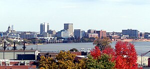
 Downtown Evansville skyline from Dreier Boulevard | |
 | |
| Country | |
| State | |
| Largest city | Evansville, Indiana |
| Other cities | – Boonville, IN – Henderson, KY – Newburgh, IN – Princeton, IN – Mount Vernon, IN |
| Area | |
• Total | 2,367 sq mi (6,130 km2) |
| Highest elevation | 595 ft (181 m) |
| Lowest elevation | 320 ft (98 m) |
| Population | |
• Total | 358,676 |
| • Rank | 160th in the U.S. |
| • Density | 152.9/sq mi (59.0/km2) |
| GDP | |
| • Total | $25.278 billion (2022) |
| Time zone | UTC−6 (CST) |
| • Summer (DST) | UTC−5 (CDT) |
History
editIt was originally designated the Evansville, Indiana, standard metropolitan area and was formed by the United States Census Bureau in 1950, consisting solely of Vanderburgh County, Indiana. As surrounding counties saw an increase in their population densities and the number of residents employed within Vanderburgh County, they met Census criteria to be added to the MSA. Four Indiana counties and two Kentucky counties are now a part of this MSA.
Because it includes counties in both Indiana and Kentucky, the Evansville metropolitan area is sometimes referred to as "Kentuckiana". The entire region is usually referred to as the Tri-State because of Illinois bordering Posey County less than 20 miles west of Evansville and to distinguish it from the Louisville metropolitan area.
Major employers
editHealthcare
edit- Deaconess Health System, Evansville and Newburgh
- St. Vincent Health, Evansville
Industrial
edit- Toyota Motor Manufacturing Indiana
Gibson County - Alcoa
Warrick County - SABIC, formerly GE Plastics
Posey County - CenterPoint Energy, formerly Vectren,[2] Operates three power plants in the area in Posey and Warrick Counties.
- Duke Energy Indiana, Operates a power plant in Gibson County.
Current populations
edit| Geographic Area | 2010 Census | 2000 Census | 1990 Census | 1980 Census | 1970 Census | 1960 Census | 1950 Census |
|---|---|---|---|---|---|---|---|
| Evansville MSA | 358,676 | 342,815 | 324,858 | 309,408 | 232,775 | 199,313 | 160,422 |
| Gibson County, Indiana | 33,503 | 32,580 | 30,159 | 29,233¹ | 28,799¹ | 28,567¹ | 27,777¹ |
| Posey County, Indiana | 25,910 | 27,061 | 25,968 | 26,414 | 21,740¹ | 19,214¹ | 19,818¹ |
| Vanderburgh County, Indiana | 179,703 | 171,922 | 165,058 | 167,515 | 168,772 | 165,794 | 160,422 |
| Warrick County, Indiana | 59,689 | 52,383 | 44,920 | 41,474 | 27,972 | 23,577¹ | 21,527¹ |
| Henderson County, Kentucky | 46,250 | 44,829 | 43,044 | 40,849 | 36,031 | 33,519 | 30,715¹ |
| Webster County, Kentucky | 13,621 | 14,120 | 13,955 | 14,832¹ | 13,282¹ | 14,244¹ | 15,555¹ |
¹ County was not a part of Evansville MSA at the time of this Census and the county's population is not included in MSA total.
See also
editReferences
edit- ^ "Total Gross Domestic Product for Evansville, IN-KY (MSA)". Federal Reserve Economic Data. Federal Reserve Bank of St. Louis.
- ^ "CenterPoint Energy & Vectren". Vectren. CenterPoint Energy. Retrieved March 27, 2021.
External links
edit- U.S. Census Bureau State & County QuickFacts Archived April 1, 2004, at the Wayback Machine
- U.S. Census Bureau population estimates at the Library of Congress Web Archives (archived December 6, 2006)
- Metropolitan and Micropolitan Statistical Areas at the Wayback Machine (archived March 9, 2008)
- About Metropolitan and Micropolitan Statistical Areas
- Historical Metropolitan Area Definitions at the Wayback Machine (archived October 9, 1999)