File:1853 U.S.C.S. Map or Chart of Northwestern Washington State ( Vancouver Island ) - Geographicus - WesternCoastUSA-uscs-1853.jpg
Size of this preview: 700 × 600 pixels. Other resolutions: 280 × 240 pixels | 561 × 480 pixels | 897 × 768 pixels | 1,196 × 1,024 pixels | 2,391 × 2,048 pixels | 4,000 × 3,426 pixels.
Original file (4,000 × 3,426 pixels, file size: 1.9 MB, MIME type: image/jpeg)
| This is a file from the Wikimedia Commons. Information from its description page there is shown below. Commons is a freely licensed media file repository. You can help. |
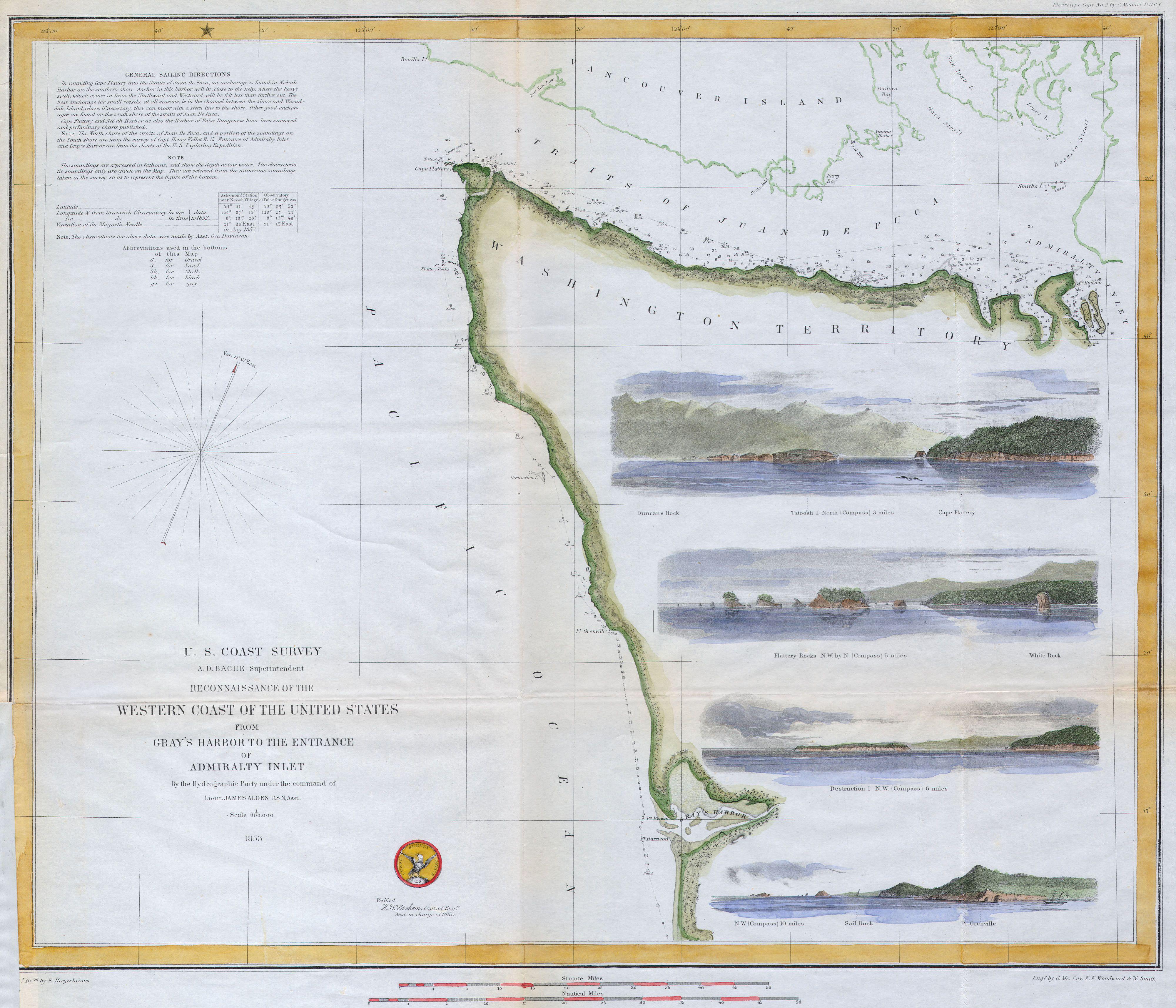
| Reconnaissance of the Western Coast of the United States from Gray’s Harbor to the Entrance of Admiralty Inlet. | ||||||
|---|---|---|---|---|---|---|
| Artist | ||||||
| Title |
Reconnaissance of the Western Coast of the United States from Gray’s Harbor to the Entrance of Admiralty Inlet. |
|||||
| Description |
English: Offered is a U.S. Coast Survey map or chart of the northwest part of Washington State and indeed, the northwestern most point of the United States. Extends from Vancouver Island in the north, through the Straits of Juan de Fuca, south as far as Gray’s Harbor. Features four attractive costal views: Sail Rock, Destruction Island, Flattery Rocks, and Tatoosh Island. Numerous nautical notes and depth soundings dominate the left-hand side of the map. Today this regions is part of the American Indian Makah Reservation and the northernmost point of the Olympic Coast National Marine Sanctuary. Dated 1853. This map was created under the direction of A. D. Bache, Superintendent of the Survey of the Coast of the United States and one of the most influential American cartographers of the 19th century. |
|||||
| Date | 1853 (dated) | |||||
| Dimensions | height: 15 in (38.1 cm); width: 17.5 in (44.4 cm) | |||||
| Accession number |
Geographicus link: WesternCoastUSA-uscs-1853 |
|||||
| Source/Photographer |
|
|||||
| Permission (Reusing this file) |
|
|||||
| Other versions | ||||||
_-_Geographicus_-_WesternCoastUSA-uscs-1853_(cropped).jpg)
_-_Geographicus_-_WesternCoastUSA-uscs-1853.jpg)
_-_Geographicus_-_WesternCoastUSA-uscs-1853.jpg&action=edit&redlink=1)
_-_Geographicus_-_WesternCoastUSA-uscs-1853.jpg)
File history
Click on a date/time to view the file as it appeared at that time.
| Date/Time | Thumbnail | Dimensions | User | Comment | |
|---|---|---|---|---|---|
| current | 01:05, 25 March 2011 | | 4,000 × 3,426 (1.9 MB) | BotMultichillT | {{subst:User:Multichill/Geographicus |link=http://www.geographicus.com/P/AntiqueMap/WesternCoastUSA-uscs-1853 |product_name=1853 U.S.C.S. Map or Chart of Northwestern Washington State ( Vancouver Island ) |map_title=Reconnaissance of the Western Coast of |
File usage
No pages on the English Wikipedia use this file (pages on other projects are not listed).
_-_Geographicus_-_WesternCoastUSA-uscs-1853.jpg)