File:AMH-7097-KB Map of Candia with the royal residence.jpg

Original file (2,400 × 2,118 pixels, file size: 1.5 MB, MIME type: image/jpeg)

Summary

Nederlands: Plattegrond van Candia met de koninklijke residentie
                     English:  Map of Kandy with the royal residence
  (Wikidata search (Cirrus search) Wikidata query (SPARQL)  Create new Wikidata item based on this file)
Author

Creator:Johann Carl Tetschner

Johann Wolfgang Heydt  (1716–1777)  wikidata:Q55915824
 
Alternative names
J.W. Heydt
Description cartographer
Date of birth/death 1716 Edit this at Wikidata 1777 Edit this at Wikidata
Authority file
creator QS:P170,Q55915824
Nederlands: Johann Carl Tetschner (uitgever), Johann Wolfgang Heydt (tekenaar en graveur)
English: Johann Carl Tetschner (publisher), Johann Wolfgang Heydt (draughtsman and engraver)
Title
Nederlands: Plattegrond van Candia met de koninklijke residentie
English: Map of Kandy with the royal residence
Description
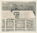
Nederlands: Plattegrond van Candia met de koninklijke residentie.

Ein Halb-Plan der Königl: Resid: Stadt Candia, nebst Einzug des Holland. Ambassad..

Linksboven: No: XC.

Rechtsboven: pag. 268.

Legenda links: a. einige eintheilung der Stadt Strassen. / b. Einzug des Ambassaderus. / c. Empfang des Ambassad. von Candisch. prem. Minister. / d. Brief. / c. Pferd. / f. und andere geschencke. / g. Parade der Singualesen und Elephanten. / h. Königlicher Garten. / i. Vorhoff. / k. Plan des Audientz. Saals, u. ander. gebäude.

Legenda rechts: Äusserliche Vorstellung der Residentz in besserer Grösse. / 1. Parade der Singualesen, vier grössert. / 2. Eingang zu einem lust u. zier-gebäude. / 3. Eingang zum Königl: Vorhoff. / 4. Gebäude worunter sich die Königl: Music und Wacht enthält. / 5. Gebäude worinn die Holländischen Ambassadeur Tractiret werden. / 6. Dach von des Königs. Vorsaal. / 7. Thürmgen, so wie es schien v. ihren Pagod..
English: Map of Kandy with the royal residence.
[Note: The correct English name for the town/kingdom is Kandy; "Candia" appears to be a latinization that can potentially lead to confusion with the "Kingdom of Candia" on Crete.]

Ein Halb-Plan der K??nigl: Resid: Stadt Kandy, nebst Einzug des Holland. Ambassad..

Top left: No: XC.

Top right: pag. 268.

Key on the left: a. einige eintheilung der Stadt Strassen. / b. Einzug des Ambassaderus. / c. Empfang des Ambassad. von Candisch. prem. Minister. / d. Brief. / c. Pferd. / f. und andere geschencke. / g. Parade der Singualesen und Elephanten. / h. Königlicher Garten. / i. Vorhoff. / k. Plan des Audientz. Saals, u. ander. gebäude.

Key on the right: Äusserliche Vorstellung der Residentz in besserer Grösse. / 1. Parade der Singualesen, vier grössert. / 2. Eingang zu einem lust u. zier-gebäude. / 3. Eingang zum Königl: Vorhoff. / 4. Gebäude worunter sich die Königl: Music und Wacht enthält. / 5. Gebäude worinn die Holländischen Ambassadeur Tractiret werden. / 6. Dach von des Königs. Vorsaal. / 7. Thürmgen, so wie es schien v. ihren Pagod..
Date 1736
date QS:P571,+1736-00-00T00:00:00Z/9
Medium
Nederlands: koperdruk op papier
English: copperplate printing on paper
Dimensions height: 29 cm (11.4 in); width: 25.5 cm (10 in)
dimensions QS:P2048,29U174728
dimensions QS:P2049,25.5U174728
institution QS:P195,Q1526131
Accession number
2102 A 7, p. 268
Inscriptions
Ein Halb-Plan der Königl: Resid: Stadt Candia, nebst Einzug des Holland. Ambassad.

author: J. W. Heydt, del: et sculp. 1736.
Notes
English: Subjects: survey / view, chart / map / plan, key, building, procession, tower, pagoda / temple, meeting / visit, house
Nederlands: Onderwerpen: overzicht / aanzicht, plattegrond / kaart, legenda, gebouw, optocht / stoet, toren, pagode / tempel, ontmoeting / bezoek, huis / woonhuis
English: Post: this image is related to a VOC trading post called Kandy
Source/Photographer Source at the Atlas of Mutual Heritage
Permission
(Reusing this file)
This is a faithful photographic reproduction of a two-dimensional, public domain work of art. The work of art itself is in the public domain for the following reason:
Public domain

This work is in the public domain in its country of origin and other countries and areas where the copyright term is the author's life plus 100 years or fewer.


You must also include a United States public domain tag to indicate why this work is in the public domain in the United States.
This file has been identified as being free of known restrictions under copyright law, including all related and neighboring rights.
The official position taken by the Wikimedia Foundation is that "faithful reproductions of two-dimensional public domain works of art are public domain".
This photographic reproduction is therefore also considered to be in the public domain in the United States. In other jurisdictions, re-use of this content may be restricted; see Reuse of PD-Art photographs for details.
Object location7° 17′ 13″ N, 80° 37′ 39″ E Kartographer map based on OpenStreetMap.View this and other nearby images on: OpenStreetMapinfo

Captions

Add a one-line explanation of what this file represents

Items portrayed in this file

depicts

7°17'12.999998"N, 80°37'39.000000"E

image/jpeg

63a342b80738b92fb58315efc8c7932761733e08

1,571,262 byte

2,118 pixel

2,400 pixel

File history

Click on a date/time to view the file as it appeared at that time.

Date/TimeThumbnailDimensionsUserComment
current12:29, 10 June 2014Thumbnail for version as of 12:29, 10 June 20142,400 × 2,118 (1.5 MB)HuskyBot== {{int:filedesc}} == {{Artwork |title = {{nl|1=Plattegrond van Candia met de koninklijke residentie}} {{en|1=Map of Candia with the royal residence}} |description = {{nl|1=Plattegrond van Candia met de konink...

The following page uses this file:

Global file usage

The following other wikis use this file: