Size of this preview: 674 × 600 pixels. Other resolutions: 270 × 240 pixels | 539 × 480 pixels | 863 × 768 pixels | 1,151 × 1,024 pixels | 2,301 × 2,048 pixels | 5,599 × 4,983 pixels.
Original file (5,599 × 4,983 pixels, file size: 10.15 MB, MIME type: image/jpeg)
File history
Click on a date/time to view the file as it appeared at that time.
| Date/Time | Thumbnail | Dimensions | User | Comment | |
|---|---|---|---|---|---|
| current | 00:48, 24 September 2013 |  | 5,599 × 4,983 (10.15 MB) | Avenue | Higher resolution |
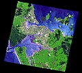
| 09:25, 8 September 2007 |  | 1,200 × 1,068 (224 KB) | Avenue | Satellite image of Auckland, New Zealand, and the islands of the inner Hauraki Gulf. Data Acquired: 2006-10-16 Corner points: * Image width = 5599 height = 4983 bands = 3 Geo Projection * Top Left -36.611691 174.364053 * Lat Increment 0.0001350000 L | |
| 09:18, 8 September 2007 |  | 5,599 × 4,983 (5.44 MB) | Avenue | Satellite image of Auckland, New Zealand, and the islands of the inner Hauraki Gulf. Data Acquired: 2006-10-16 Corner points: Image width = 5599 height = 4983 bands = 3 Geo Projection Top Left -36.611691 174.364053 Lat Increment 0.0001350000 Long |
File usage
No pages on the English Wikipedia use this file (pages on other projects are not listed).
Global file usage
The following other wikis use this file:
- Usage on gu.wikipedia.org
- Usage on kn.wikipedia.org
- Usage on nn.wikipedia.org


