Size of this preview: 584 × 600 pixels. Other resolutions: 234 × 240 pixels | 467 × 480 pixels | 892 × 916 pixels.
Original file (892 × 916 pixels, file size: 267 KB, MIME type: image/jpeg)
File history
Click on a date/time to view the file as it appeared at that time.
| Date/Time | Thumbnail | Dimensions | User | Comment | |
|---|---|---|---|---|---|
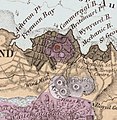
| current | 05:21, 21 November 2021 |  | 892 × 916 (267 KB) | Prosperosity | == {{int:filedesc}} == {{Information |Description=The Albert Park Volcano superimposed onto the 1859 township of Auckland, with the Grafton Volcano to the sough. Portion of a map of the Auckland Volcanic Field by Ferdinand von Hochstetter, 1859. Originally published in Geologisch-topographischer Atlas von Neu-Seeland (Hochstetter and Petermann, 1863), and republished in English in 1864. |Source=Original downloaded from http://www.gsnz.org.nz/auck_branch/mangere_w... |
File usage
The following page uses this file: