File:Basin analysis and stratigraphy in outcrop with major sequence boundary and fossil submarine canyon.png
Size of this preview: 800 × 542 pixels. Other resolutions: 320 × 217 pixels | 640 × 434 pixels | 1,024 × 694 pixels | 1,280 × 867 pixels | 2,308 × 1,564 pixels.
Original file (2,308 × 1,564 pixels, file size: 2.36 MB, MIME type: image/png)
| This is a file from the Wikimedia Commons. Information from its description page there is shown below. Commons is a freely licensed media file repository. You can help. |
Summary
| Description |
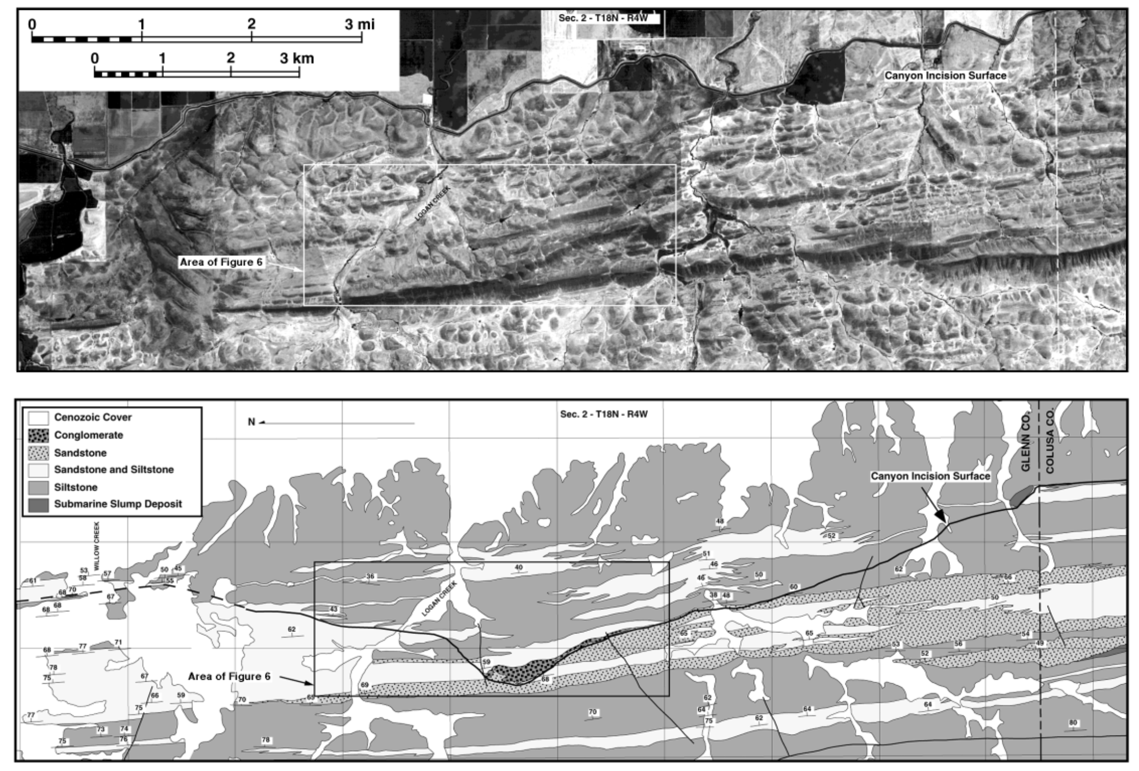
English: Example of sedimentary basin analysis using traditional surface geologic mapping in combination with aerial photography. In this case identifying a significant sequence boundary resulting from the erosion and filling of a submarine canyon thousands of feet deep. This example is from the Upper Cretaceous Great Valley Group and is located near the town of Willows, California
Source: Williams, T.A., 1997, Basin-fill architecture and forearc tectonics, Cretaceous Great Valley Group, Sacramento basin, northern California [Ph.D. thesis]: Stanford,California, Stanford University, 412 p. |
| Date | |
| Source | Own work |
| Author | RockDr |
Licensing
I, the copyright holder of this work, hereby publish it under the following license:
This file is licensed under the Creative Commons Attribution-Share Alike 4.0 International license.
- You are free:
- to share – to copy, distribute and transmit the work
- to remix – to adapt the work
- Under the following conditions:
- attribution – You must give appropriate credit, provide a link to the license, and indicate if changes were made. You may do so in any reasonable manner, but not in any way that suggests the licensor endorses you or your use.
- share alike – If you remix, transform, or build upon the material, you must distribute your contributions under the same or compatible license as the original.
File history
Click on a date/time to view the file as it appeared at that time.
| Date/Time | Thumbnail | Dimensions | User | Comment | |
|---|---|---|---|---|---|
| current | 01:32, 4 September 2022 | | 2,308 × 1,564 (2.36 MB) | RockDr | Uploaded while editing "User:RockDr/sandbox" on en.wikipedia.org |
File usage
The following pages on the English Wikipedia use this file (pages on other projects are not listed):