File:Battle of Kum River 14Jul1950.jpg

Original file (1,000 × 1,319 pixels, file size: 253 KB, MIME type: image/jpeg)

Summary

Description
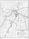
English: Map of the US 34th Infantry Regiment's defense at the Kum River, July 14, 1950
Date
Source http://www.koreanwar.org/html/maps_cmh.html, map as originally published in South to the Naktong, North to the Yalu by Roy Appleman, US Army historian (1992). Color added by Ed!
Author Center of Military History, United States Army
Other versions (original map)

Licensing

Public domain
This file is a work of a U.S. Army soldier or employee, taken or made as part of that person's official duties. As a work of the U.S. federal government, it is in the public domain in the United States.

العربية  বাংলা  català  čeština  Deutsch  English  español  eesti  فارسی  suomi  français  hrvatski  magyar  Bahasa Indonesia  italiano  日本語  한국어  lietuvių  македонски  മലയാളം  မြန်မာဘာသာ  Nederlands  polski  português  русский  sicilianu  српски / srpski  Türkçe  українська  Tiếng Việt  中文(简体)  中文(繁體)  +/−

Captions

Add a one-line explanation of what this file represents

Items portrayed in this file

depicts

image/jpeg

312a00ab8b07fbc521c07a189a015558ab6c892a

258,665 byte

1,319 pixel

1,000 pixel

File history

Click on a date/time to view the file as it appeared at that time.

Date/TimeThumbnailDimensionsUserComment
current04:24, 6 April 2010Thumbnail for version as of 04:24, 6 April 20101,000 × 1,319 (253 KB)Ed!{{Information |Description={{en|1=== Summary == {{Information |Description={{en|1=Map of the US 34th Infantry Regiment's defense at the Kum River, July 14, 1950}} |Source=http://www.koreanwar.org/html/maps_cmh.html, map as originally published in [http://
No pages on the English Wikipedia use this file (pages on other projects are not listed).
Metadata