Size of this preview: 688 × 600 pixels. Other resolutions: 275 × 240 pixels | 551 × 480 pixels | 881 × 768 pixels | 1,175 × 1,024 pixels | 2,350 × 2,048 pixels | 3,699 × 3,224 pixels.
Original file (3,699 × 3,224 pixels, file size: 759 KB, MIME type: image/png)
File history
Click on a date/time to view the file as it appeared at that time.
| Date/Time | Thumbnail | Dimensions | User | Comment | |
|---|---|---|---|---|---|
| current | 04:50, 5 March 2023 |  | 3,699 × 3,224 (759 KB) | Allice Hunter | Cropped 10 % horizontally, 9 % vertically using CropTool with precise mode. |
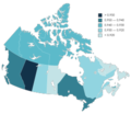
| 04:48, 5 March 2023 |  | 4,115 × 3,556 (1,020 KB) | Allice Hunter | Uploaded a work by MapChart from * Base map: [https://www.mapchart.net/canada.html MapChart Canada] * Global Data Lab: {{Cite web |title=Sub-national HDI - Subnational HDI - Global Data Lab |url=https://globaldatalab.org/shdi/table/shdi/CAN/?levels=1+4&years=2021&interpolation=0&extrapolation=0 |url-status=live |access-date= |website=globaldatalab.org}} with UploadWizard |
File usage
The following page uses this file:
Global file usage
The following other wikis use this file:
- Usage on pt.wikipedia.org