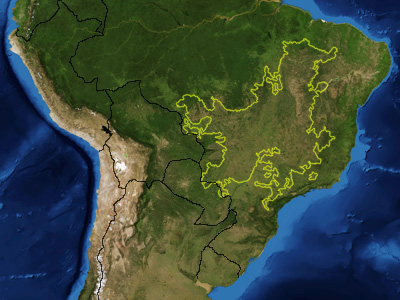
Cerrado_ecoregion.jpg (400 × 300 pixels, file size: 100 KB, MIME type: image/jpeg)
File history
Click on a date/time to view the file as it appeared at that time.
| Date/Time | Thumbnail | Dimensions | User | Comment | |
|---|---|---|---|---|---|
| current | 05:36, 18 January 2007 |  | 400 × 300 (100 KB) | Pfly | {{Information |Description=This is a map showing the location of the Cerrado ecoregion as delineated by the World Wide Fund for Nature. I, Pfly, made it using NASA Blue Marb |
File usage
The following 2 pages use this file:
Global file usage
The following other wikis use this file:
- Usage on ar.wikipedia.org
- Usage on ast.wikipedia.org
- Usage on azb.wikipedia.org
- Usage on bg.wikipedia.org
- Usage on ca.wikipedia.org
- Usage on ceb.wikipedia.org
- Usage on cs.wikipedia.org
- Usage on de.wikipedia.org
- Usage on en.wiktionary.org
- Usage on eo.wikipedia.org
- Usage on es.wikipedia.org
- Usage on fi.wikipedia.org
- Usage on fr.wikipedia.org
- Usage on gl.wikipedia.org
- Usage on he.wikipedia.org
- Usage on hr.wikipedia.org
- Usage on hu.wikipedia.org
- Usage on it.wikipedia.org
- Usage on ml.wikipedia.org
- Usage on nl.wikipedia.org
- Usage on no.wikipedia.org
- Usage on pl.wikipedia.org
- Usage on pt.wikipedia.org
- Cerrado
- Vegetação do Brasil
- Hypocephalus armatus
- Polinizadores do cerrado
- Usuário(a):Casadopovo/Eurafrica
- Wikipédia:Wiki Loves Monuments 2019/Brasil/Lista/Tocantins
- Wikipédia:Wiki Loves Monuments 2019/Brasil/Lista/Bahia
- Wikipédia:Wiki Loves Monuments 2019/Brasil/Lista/Maranhão
- Wikipédia:Wiki Loves Monuments 2019/Brasil/Lista/Distrito Federal
View more global usage of this file.


