File:Chugwater Soda Fountain.jpg

Original file (4,000 × 3,000 pixels, file size: 2.66 MB, MIME type: image/jpeg)

Summary

Description

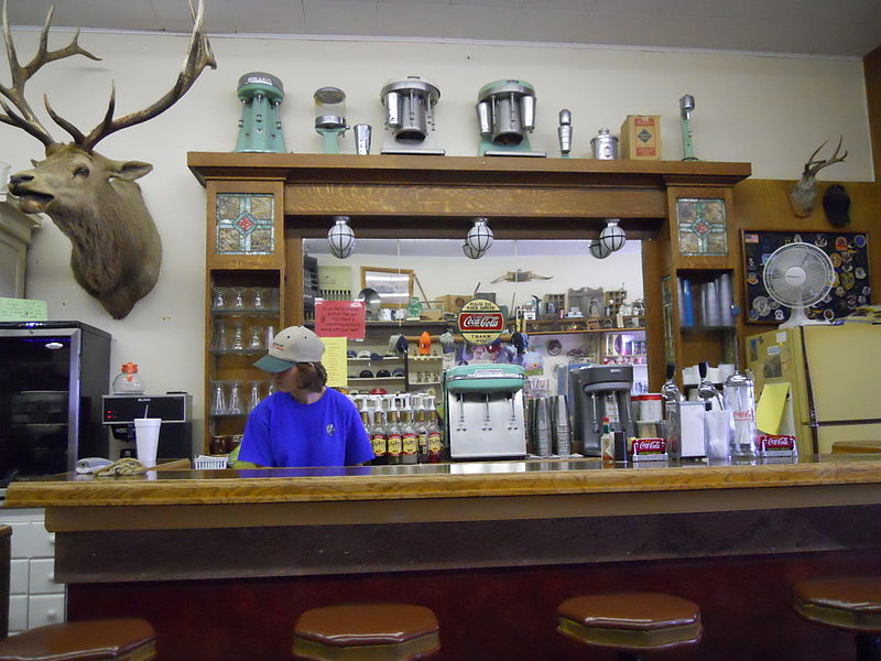
The History of the Chugwater Soda Fountain The Oldest Operating Soda fountain in Wyoming

The Soda fountain is housed in one of the oldest buildings in Chugwater. The building was built in 1914, later, partially burned down, and was rebuilt in 1916. It has been a Doctor's office and a pharmacy. There was a small apartment in the back where the doctor and his family lived. The pharmacy drawers are still intact along one wall of the store.

The soda fountain bar was built in England and installed in a business in Rock Creek WY. when the Railroad went through in 1927, the town moved to Tock River. The owner was not interested in moving his business, so he sold his equipment to the owner of the pharmacy in Chugwater. The bar was broken aprt into three pieces - the main bar, the top(including the mirror), and the bottom cabinets. It was then packed into wagons and transported over the mountains to be installed in this building. The mirror and glass are all original; you can stand in the back and see the curve in the mirror.1

The pharmacy and soda fountain co-existed for some time, but eventually one of the owners no longer had a pharmacy license and the store became a soda fountain only. Ownership has changed hands many times, with different people making various changes.

The large elk overlooking the room is nicknamed "Wendall" for the man who shot him. He was shot near Jackson, WY in 1946 and has resided in the soda fountain since 1947. A town petition prevents Wendall from leaving, no matter who owns it.

Over time, different owners have added components like the small package liquor store, "diner", and the Beer Garden in the summer. It remains one of few active soda fountains in the state that serves traditional, hand dipped ice cream shakes and malts.
Date
Source Chugwater Soda Fountain
Author Konrad Summers from Santa Clarita (Valencia) , California, USA
Camera location41° 45′ 25.83″ N, 104° 49′ 15.63″ W Kartographer map based on OpenStreetMap.View this and other nearby images on: OpenStreetMapinfo

Licensing

w:en:Creative Commons
attribution share alike
This file is licensed under the Creative Commons Attribution-Share Alike 2.0 Generic license.
You are free:
  • to share – to copy, distribute and transmit the work
  • to remix – to adapt the work
Under the following conditions:
  • attribution – You must give appropriate credit, provide a link to the license, and indicate if changes were made. You may do so in any reasonable manner, but not in any way that suggests the licensor endorses you or your use.
  • share alike – If you remix, transform, or build upon the material, you must distribute your contributions under the same or compatible license as the original.
This image was originally posted to Flickr by tkksummers at https://www.flickr.com/photos/12806074@N08/4712851275. It was reviewed on 14 July 2015 by FlickreviewR and was confirmed to be licensed under the terms of the cc-by-sa-2.0.

14 July 2015

Captions

Add a one-line explanation of what this file represents

Items portrayed in this file

depicts

13 June 2010

41°45'25.830"N, 104°49'15.625"W

image/jpeg

cd08bae86474b40341dc50472961c71af29bf005

2,788,579 byte

3,000 pixel

4,000 pixel

File history

Click on a date/time to view the file as it appeared at that time.

Date/TimeThumbnailDimensionsUserComment
current21:22, 14 July 2015Thumbnail for version as of 21:22, 14 July 20154,000 × 3,000 (2.66 MB)TillmanTransferred from Flickr via Flickr2Commons

Global file usage

The following other wikis use this file:

Metadata