
Size of this PNG preview of this SVG file: 369 × 599 pixels. Other resolutions: 148 × 240 pixels | 296 × 480 pixels | 473 × 768 pixels | 631 × 1,024 pixels | 1,262 × 2,048 pixels | 4,802 × 7,792 pixels.
Original file (SVG file, nominally 4,802 × 7,792 pixels, file size: 200 KB)
| This is a file from the Wikimedia Commons. Information from its description page there is shown below. Commons is a freely licensed media file repository. You can help. |
Summary
| Description |
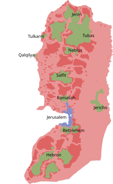
English: Control status of the West Bank as per the Oslo Accords |
| Date | |
| Source | Own work |
| Author | SoWhAt249 |
Русский: Статус территорий Западного берега реки Иордан в соответствии с соглашениями в Осло:
Аннексировано Израилем
Зона A: Под палестинским военным и гражданским контролем
Зона B: Под израильским и палестинским военным и палестинским гражданским контролем
Зона C: Под израильским военным и гражданским контролем
English: Control status of the West Bank as per the Oslo Accords:
Annexed by Israel
Area A: Palestinian security and civil control
Area B: Joint security and Palestinian civil control
Area C: Israeli security and civil control
Македонски: Контролен статус на западниот брег според Договорот Осло:
Анексирано од Израел
Област A: Палестинска безбедносна и граѓанска контрола
Област Б: Заедничка безбедносна и палестинска граѓанска контрола
Област Ц: Израелска безбедносна и граѓанска контрола
فارسی: وضعیت کنترل کرانه باختری براساس توافقنامهی اسلو:
نواحی ضمیمهشده به اسرائیل
منطقهی A: تحت کنترل نیروی مدنی و خدمات امنیتی تشکیلات خودگردان فلسطین
منطقهی B: منطقهی امنیتی مشترک بین نیروهای امنیتی و مدنی اسرائیل و نیروی مدنی و خدمات امنیتی تشکیلات خودگردان فلسطین
منطقهی C: تحت کنترل نیروهای امنیتی و مدنی اسرائیل
Licensing
I, the copyright holder of this work, hereby publish it under the following license:
This file is licensed under the Creative Commons Attribution-Share Alike 4.0 International license.
- You are free:
- to share – to copy, distribute and transmit the work
- to remix – to adapt the work
- Under the following conditions:
- attribution – You must give appropriate credit, provide a link to the license, and indicate if changes were made. You may do so in any reasonable manner, but not in any way that suggests the licensor endorses you or your use.
- share alike – If you remix, transform, or build upon the material, you must distribute your contributions under the same or compatible license as the original.
File history
Click on a date/time to view the file as it appeared at that time.
| Date/Time | Thumbnail | Dimensions | User | Comment | |
|---|---|---|---|---|---|
| current | 13:08, 10 September 2022 | | 4,802 × 7,792 (200 KB) | أحمد الناصر | File uploaded using svgtranslate tool (https://svgtranslate.toolforge.org/). Added translation for ar. |
| 18:33, 3 August 2020 |  | 4,802 × 7,792 (249 KB) | Aleksei m | Adding the name of the capitals of the districts. According to [https://web.archive.org/web/20160304194409/http://www.passia.org/images/meetings/2015/Material%20for%20the%20Website/Government%20(2015).pdf Passia]. | |
| 00:20, 16 November 2017 |  | 4,802 × 7,792 (196 KB) | Leokand | Удалено описание — пренесено в текстовую легенду | |
| 15:42, 14 November 2017 |  | 4,802 × 7,792 (188 KB) | Guanaco | Reverted to version as of 18:50, 13 November 2017 (UTC) | |
| 15:27, 14 November 2017 |  | 744 × 1,052 (283 KB) | SoWhAt249 | The same map in Russian. | |
| 18:50, 13 November 2017 |  | 4,802 × 7,792 (188 KB) | Guanaco | resize page to selection so the whole image will display | |
| 18:06, 13 November 2017 |  | 744 × 1,052 (283 KB) | SoWhAt249 | User created page with UploadWizard |
File usage
The following 5 pages use this file:
Global file usage
The following other wikis use this file:
- Usage on ar.wikipedia.org
- Usage on arz.wikipedia.org
- Usage on ast.wikipedia.org
- Usage on az.wikipedia.org
- Usage on bn.wikipedia.org
- Usage on ca.wikipedia.org
- Usage on ceb.wikipedia.org
- Usage on ckb.wikipedia.org
- Usage on cs.wikipedia.org
- Usage on de.wikipedia.org
- Usage on de.wikivoyage.org
- Usage on diq.wikipedia.org
- Usage on el.wikipedia.org
- Usage on eo.wikipedia.org
- Usage on es.wikipedia.org
- Usage on eu.wikipedia.org
- Usage on fr.wikipedia.org
- Usage on ga.wikipedia.org
- Usage on gl.wikipedia.org
View more global usage of this file.