No higher resolution available.
Crimea_2nd_century_BC_map.png (430 × 335 pixels, file size: 30 KB, MIME type: image/png)
| This is a file from the Wikimedia Commons. Information from its description page there is shown below. Commons is a freely licensed media file repository. You can help. |
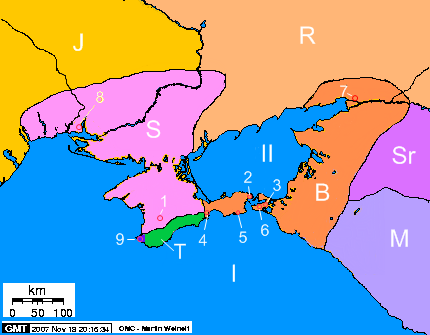
Description of the map-Opis mapy:
- Seas - morza
- I) Black Sea – Morze Czarne
- II) Sea of Azov - Morze Azowskie
- I) Black Sea – Morze Czarne
- Cities - miasta
- 1) Scythians Neapolis - Neapol Scytyjski
- 2) Panticapaeum - Pantikapajon
- 3) Phanagoria - Fanagoria
- 4) Feodosiya - Teodozja
- 5) Kimmerikon
- 6) Hermonassa
- 7) Tanais
- 8) Olbia
- 9) Chersonesos - Chersonez Taurydzki
- 1) Scythians Neapolis - Neapol Scytyjski
- Peoples and states – Ludy i państwa
- S) State of Scythians on Crimea – Państwo scytyjskie na Krymia
- B) Bosporan Kingdom – Królestwo Bosporańskie
- J) Iazyges - Jazygowie
- R) Rhoxolani - Roksolanie
- Sr) Siraces - Syrakowie
- M) Maeotae – Meotowie
- T) Tauri - Taurowie
- S) State of Scythians on Crimea – Państwo scytyjskie na Krymia
| Description |
English: The map of Crimea, 2 century BC
Polski: Krym w II wieku p.n.e. |
||
| Date | 15.09 - 19.11.2007 | ||
| Source | Own work, on the basis of publications: "Atlas Historii Świata"( Atlas of the World's History, Warszawa - Wrocław, edit. PPWK, 1986), Smirnov A. "Scytowie" (Scythians, edit. PIW, Warszawa, 1974), and maps from WWW: [1], [2] | ||
| Author | Janmad | ||
| Permission (Reusing this file) |
I, the copyright holder of this work, hereby publish it under the following licenses:
This file is licensed under the Creative Commons Attribution 3.0 Unported license.
You may select the license of your choice. |

![[1]](http://aors.narod.ru/images/Sarmat.gif)
File history
Click on a date/time to view the file as it appeared at that time.
| Date/Time | Thumbnail | Dimensions | User | Comment | |
|---|---|---|---|---|---|
| current | 15:02, 19 November 2007 | | 430 × 335 (30 KB) | Janmad | after changes |
| 04:31, 21 September 2007 |  | 328 × 207 (23 KB) | Janmad | small change in colour | |
| 04:11, 21 September 2007 |  | 328 × 207 (23 KB) | Janmad | changes on the basis of map [http://www.sevastopol-adm.gov.ua/cityinfo/history/hersones/p_4_c121/] | |
| 05:26, 16 September 2007 |  | 328 × 207 (23 KB) | Janmad | Description of the map-Opis mapy: I)Black Sea – Morze Czarne II)Sea of Azov - Morze Azowskie 1)Scythians Neapolis - Neapol Scytyjski 2)Panticapaeum - Pantikapajon 3)Phanagoria - Fanagoria 4)Feodosiya - Teodozja 5)Kimmerikon 6)Hermonassa 7)Tanais 8)Olbia |
File usage
The following page uses this file:
Global file usage
The following other wikis use this file:
- Usage on ba.wikipedia.org
- Usage on cv.wikipedia.org
- Usage on de.wikipedia.org
- Usage on fa.wikipedia.org
- Usage on hu.wikipedia.org
- Usage on hy.wikipedia.org
- Usage on it.wikipedia.org
- Usage on kk.wikipedia.org
- Usage on ko.wikipedia.org
- Usage on la.wikipedia.org
- Usage on nl.wikipedia.org
- Usage on pl.wikipedia.org
- Usage on ru.wikipedia.org
- Usage on uk.wikipedia.org
- Usage on uz.wikipedia.org
- Usage on www.wikidata.org