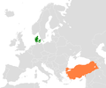
Size of this preview: 800 × 514 pixels. Other resolutions: 320 × 206 pixels | 640 × 412 pixels | 1,024 × 659 pixels | 1,280 × 823 pixels | 1,936 × 1,245 pixels.
Original file (1,936 × 1,245 pixels, file size: 107 KB, MIME type: image/png)
File history
Click on a date/time to view the file as it appeared at that time.
| Date/Time | Thumbnail | Dimensions | User | Comment | |
|---|---|---|---|---|---|
| current | 16:48, 21 January 2012 |  | 1,936 × 1,245 (107 KB) | Phoenix B 1of3 | Faroe Islands |
| 16:30, 21 January 2012 |  | 1,936 × 1,245 (107 KB) | Phoenix B 1of3 | Border stretch | |
| 03:45, 21 January 2012 |  | 1,828 × 1,245 (102 KB) | Phoenix B 1of3 | Greenland | |
| 15:10, 23 August 2008 |  | 1,200 × 1,000 (65 KB) | Turkish Flame~commonswiki | changed with larger version | |
| 07:37, 23 August 2008 |  | 1,234 × 1,245 (78 KB) | Turkish Flame~commonswiki | {{Information |Description= Location of Denmark and Turkey |Source=self-made |Date= 23.08.2008 |Author= Turkish Flame |Permission= {{GFDL}} |other_versions= none }} Category:Maps of Turkey Category:Maps of Denmark [[Categor |
File usage
The following 2 pages use this file:
Global file usage
The following other wikis use this file:
- Usage on az.wikipedia.org
- Usage on he.wikipedia.org
- Usage on hy.wikipedia.org
- Usage on ru.wikipedia.org
- Usage on tr.wikipedia.org
- Usage on uz.wikipedia.org
- Usage on www.wikidata.org
