Size of this preview: 422 × 599 pixels. Other resolutions: 169 × 240 pixels | 451 × 640 pixels.
Original file (451 × 640 pixels, file size: 142 KB, MIME type: image/jpeg)
| This is a file from the Wikimedia Commons. Information from its description page there is shown below. Commons is a freely licensed media file repository. You can help. |
Summary
| Description |
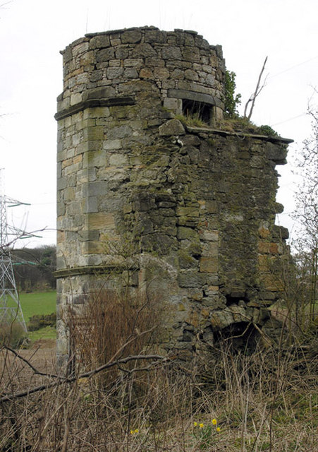
English: Dunipace House Dovecot April 2006 This remnant of an old Dunipace mansion house was converted (before 1794) to a Dovecot and used by the new Dunipace House about 100 metres due west (demolished in the 1940s). More information can be found in the Falkirk Local History Society periodical, Calatria Volume 1, Autumn 1991 and available through most local (central Scotland) libraries. The article is on Doocots (dovecots) in Falkirk District. The roof was a circular slated structure finished at the top with a decorative lantern through which the doves could enter. The structure is a Category B Listed Building in very poor condition. |
| Date | |
| Source | From geograph.org.uk |
| Author | Nigel J C Turnbull |
| Attribution (required by the license) | Nigel J C Turnbull / Dunipace House Dovecot April 2006 / |
| Camera location | | View this and other nearby images on: OpenStreetMap |
|---|
_heading:22.00&language=en)
| Object location | | View this and other nearby images on: OpenStreetMap |
|---|
_heading:22.00&language=en)
|
This is a photo of listed building number 3958. |
Licensing

|
This image was taken from the Geograph project collection. See this photograph's page on the Geograph website for the photographer's contact details. The copyright on this image is owned by Nigel J C Turnbull and is licensed for reuse under the Creative Commons Attribution-ShareAlike 2.0 license.
|
This file is licensed under the Creative Commons Attribution-Share Alike 2.0 Generic license.
Attribution: Nigel J C Turnbull
- You are free:
- to share – to copy, distribute and transmit the work
- to remix – to adapt the work
- Under the following conditions:
- attribution – You must give appropriate credit, provide a link to the license, and indicate if changes were made. You may do so in any reasonable manner, but not in any way that suggests the licensor endorses you or your use.
- share alike – If you remix, transform, or build upon the material, you must distribute your contributions under the same or compatible license as the original.
File history
Click on a date/time to view the file as it appeared at that time.
| Date/Time | Thumbnail | Dimensions | User | Comment | |
|---|---|---|---|---|---|
| current | 07:35, 4 February 2011 | | 451 × 640 (142 KB) | GeographBot | == {{int:filedesc}} == {{Information |description={{en|1=Dunipace House Dovecot April 2006 This remnant of an old Dunipace mansion house was converted (before 1794) to a Dovecot and used by the new Dunipace House about 100 metres due west (demolished in t |
File usage
The following pages on the English Wikipedia use this file (pages on other projects are not listed):