Size of this PNG preview of this SVG file: 582 × 392 pixels. Other resolutions: 320 × 216 pixels | 640 × 431 pixels | 1,024 × 690 pixels | 1,280 × 862 pixels | 2,560 × 1,724 pixels.
Original file (SVG file, nominally 582 × 392 pixels, file size: 254 KB)
File history
Click on a date/time to view the file as it appeared at that time.
| Date/Time | Thumbnail | Dimensions | User | Comment | |
|---|---|---|---|---|---|
| current | 15:42, 15 October 2010 |  | 582 × 392 (254 KB) | Tazadeperla | REDRAWN |
| 06:42, 28 September 2010 |  | 853 × 625 (199 KB) | Tazadeperla | The Belgium Army's fall back to Dyle line is now included. | |
| 09:14, 20 September 2010 |  | 853 × 625 (183 KB) | Tazadeperla | Expanded to include more information. | |
| 16:12, 19 September 2010 |  | 760 × 580 (157 KB) | Tazadeperla | Expanded to include Escaut Plan | |
| 13:39, 18 September 2010 |  | 654 × 580 (136 KB) | Tazadeperla | Color sync. | |
| 08:45, 14 September 2010 |  | 654 × 580 (135 KB) | Tazadeperla | MORE INFOS ADDED | |
| 04:24, 14 September 2010 |  | 654 × 580 (100 KB) | Tazadeperla | River names fixed. | |
| 03:52, 14 September 2010 |  | 654 × 580 (79 KB) | Tazadeperla | With border mistake fixed. | |
| 03:47, 14 September 2010 |  | 1,024 × 768 (72 KB) | Tazadeperla | With border enlarged. | |
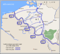
| 03:40, 14 September 2010 |  | 1,024 × 768 (71 KB) | Tazadeperla | {{Information |Description={{en|1=The Dyle Plan by Marshall Maurice Gameline.}} |Source={{own}}, redrawn from [http://www.ibiblio.org/hyperwar/UN/UK/UK-NWE-Flanders/UK-NWE-Flanders-2.html here] |Author=Taza |Date= |Permission= |oth |
File usage
The following page uses this file:
Global file usage
The following other wikis use this file:
- Usage on vi.wikipedia.org
