
Size of this preview: 450 × 600 pixels. Other resolutions: 180 × 240 pixels | 360 × 480 pixels | 576 × 768 pixels | 768 × 1,024 pixels | 1,536 × 2,048 pixels | 3,024 × 4,032 pixels.
Original file (3,024 × 4,032 pixels, file size: 1.91 MB, MIME type: image/jpeg)
| This is a file from the Wikimedia Commons. Information from its description page there is shown below. Commons is a freely licensed media file repository. You can help. |
Summary
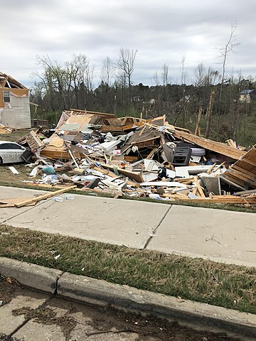
| Description | A home, along Fairview Drive in Newnan, Georgia, completely leveled by a violent EF4 tornado on March 25–26, 2021. The National Weather Service rated the damage at this location EF4 on the Enhanced Fujita scale with winds estimated at 170 miles per hour (270 km/h). The National Weather Service damage survey team also said the following about this location: “Possible EF4 point. 2 houses both totally destroyed in this section.” |
| Date | |
| Source | NOAA’s Damage Assessment Toolkit: https://apps.dat.noaa.gov/StormDamage/DamageViewer/ (Exact URL) |
| Author | NWS Peach Tree City |
| Permission (Reusing this file) |
National Weather Service |
| Camera location | | View this and other nearby images on: OpenStreetMap |
|---|
Licensing
This file is in the public domain in the United States because it was solely created by employees of the National Weather Service or National Severe Storms Laboratory using the Damage Assessment Toolkit (DAT), an interactive map and database.
|
File history
Click on a date/time to view the file as it appeared at that time.
| Date/Time | Thumbnail | Dimensions | User | Comment | |
|---|---|---|---|---|---|
| current | 05:19, 4 April 2021 | | 3,024 × 4,032 (1.91 MB) | TornadoInformation12 | {{Information |Description=Low-end EF4 damage to a house that was completely leveled in Newnan, Georgia. |Source=https://apps.dat.noaa.gov/StormDamage/DamageViewer/ |Date=April 4, 2021 |Author=NWS Peach Tree City |Permission=National Weather Service |other_versions= }} |
File usage
The following pages on the English Wikipedia use this file (pages on other projects are not listed):