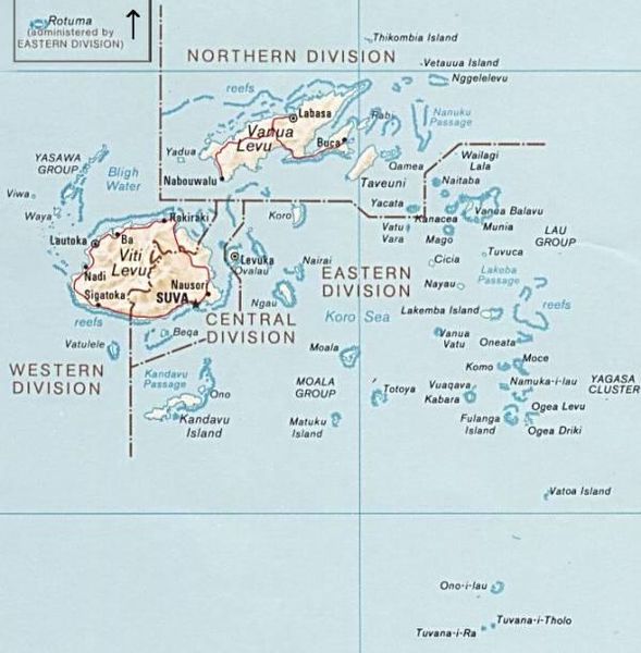
Size of this preview: 589 × 600 pixels. Other resolutions: 236 × 240 pixels | 600 × 611 pixels.
Original file (600 × 611 pixels, file size: 50 KB, MIME type: image/jpeg)
File history
Click on a date/time to view the file as it appeared at that time.
| Date/Time | Thumbnail | Dimensions | User | Comment | |
|---|---|---|---|---|---|
| current | 12:51, 30 June 2010 |  | 600 × 611 (50 KB) | Telim tor | exchanged positions of Tuvana-i-Ra and Tuvana-i-Tholo (i-Ra is the southwestern one, see also [http://www.un.org/Depts/Cartographic/map/profile/Fiji.pdf this map] (PDF) |
| 19:45, 27 November 2006 |  | 600 × 611 (48 KB) | Electionworld | {{ew|en|Pascal}} PNG map of Fiji from CIA World Factbook. {{PD-USGov-CIA-WF}} Category:Maps of Fiji |
File usage
The following page uses this file:
Global file usage
The following other wikis use this file:
- Usage on avk.wikipedia.org
- Usage on az.wikipedia.org
- Usage on be.wikipedia.org
- Usage on cs.wikipedia.org
- Usage on de.wikipedia.org
- Usage on es.wikinews.org
- Usage on io.wikipedia.org
- Usage on ka.wikipedia.org
- Usage on pl.wikipedia.org
- Usage on ru.wikipedia.org
- Usage on tr.wikipedia.org
- Usage on uk.wikipedia.org
- Usage on www.wikidata.org

