No higher resolution available.
Fort_Proctor.jpg (448 × 336 pixels, file size: 68 KB, MIME type: image/jpeg)
| This is a file from the Wikimedia Commons. Information from its description page there is shown below. Commons is a freely licensed media file repository. You can help. |
Summary
| Description |
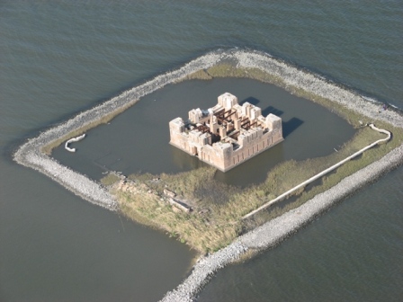
English: This is Fort Proctor from 600 feet over Bayou Yscloskey |
| Date | |
| Source | Own work |
| Author | Eric Botnick |
| Permission (Reusing this file) |
OTS |
| Object location | | View this and other nearby images on: OpenStreetMap |
|---|
Coordinates of Fort - N 29 52.1 W 89 40.7
Licensing
I, the copyright holder of this work, hereby publish it under the following license:
This file is licensed under the Creative Commons Attribution 3.0 Unported license.
- You are free:
- to share – to copy, distribute and transmit the work
- to remix – to adapt the work
- Under the following conditions:
- attribution – You must give appropriate credit, provide a link to the license, and indicate if changes were made. You may do so in any reasonable manner, but not in any way that suggests the licensor endorses you or your use.
File history
Click on a date/time to view the file as it appeared at that time.
| Date/Time | Thumbnail | Dimensions | User | Comment | |
|---|---|---|---|---|---|
| current | 05:48, 24 November 2008 | | 448 × 336 (68 KB) | Ih guy | {{Information |Description={{en|1=This is Fort Proctor from 600 feet over Bayou Yscloskey}} |Source=Own work by uploader |Author=Eric Botnick |Date=Nov 23, 2008 |Permission=OTS |other_versions= }} Coordinates of Fort - N 29 52.1 W 89 40.7 <!--{{ImageUploa |
File usage
The following 2 pages use this file:
Global file usage
The following other wikis use this file:
- Usage on arz.wikipedia.org
- Usage on www.wikidata.org