Size of this preview: 720 × 599 pixels. Other resolutions: 288 × 240 pixels | 577 × 480 pixels | 923 × 768 pixels | 1,230 × 1,024 pixels | 1,361 × 1,133 pixels.
Original file (1,361 × 1,133 pixels, file size: 569 KB, MIME type: image/jpeg)
File history
Click on a date/time to view the file as it appeared at that time.
| Date/Time | Thumbnail | Dimensions | User | Comment | |
|---|---|---|---|---|---|
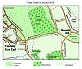
| current | 13:17, 19 July 2008 |  | 1,361 × 1,133 (569 KB) | Welkinridge | {{Information |Description=An updated version of the previous image with additional road names. |Source=Self made |Date=19th July 2008 |Author=~~~~ |Permission= |other_versions= }} |
| 12:05, 19 July 2008 |  | 1,361 × 1,133 (553 KB) | Welkinridge | {{Information |Description={{en|1=This is a map of Fortis Green in north London in about 1815. The map has been drawn by me from other maps of the time.}} |Source=Own work by uploader |Author=Welkinridge |Date=19th July 2008 |Permiss |
File usage
The following page uses this file: