File:Gros Honter County Josephinische Landesaufnahme, 1782-85.jpg

Original file (800 × 830 pixels, file size: 724 KB, MIME type: image/jpeg)

Summary

Description
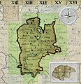
English: Gros Honter County Josephinische Landesaufnahme, 1782-85.
Slovenčina: Hontianska župa, Jozefinské mapovanie,1782-1785
Magyar: Hont vármegye, az első katonai felmérés térképén, 1782-1785
Română: Comitatul Honter în Harta Iosefină a Regatului Ungariei, 1782-85.
Date
Source File:KingdomOfHungary Josephinische Landesaufnahme Original Map 1782-1785.jpg
Author Asybaris01

Clickable Map of the Gros Honter County

Kingdom of Hungary counties(clickable map)Page 12-11:Page 12-12:Page 12-13:Page 12-14:Page 12-15:Page 12-16:Page 13-11:Page 13-12:Page 13-13:Page 13-14:Page 13-15:Page 13-16:Page 13-17:Page 13-18:Page 14-11:Page 14-12:Page 14-13:Page 14-14:Page 14-15:Page 14-16:Page 14-17:Page 15-11:Page 15-12:Page 15-13:Page 15-14:Page 15-15:RO/HU/DE/LegendOriginal maps of the Kingdom of Hungary
Josephinische Landesaufnahme. Senzitive map of the Gros Honter county, 1782-1785. (Click on the desired quadrant)


Licensing

I, the copyright holder of this work, hereby publish it under the following license:
w:en:Creative Commons
attribution share alike
This file is licensed under the Creative Commons Attribution-Share Alike 3.0 Unported license.
You are free:
  • to share – to copy, distribute and transmit the work
  • to remix – to adapt the work
Under the following conditions:
  • attribution – You must give appropriate credit, provide a link to the license, and indicate if changes were made. You may do so in any reasonable manner, but not in any way that suggests the licensor endorses you or your use.
  • share alike – If you remix, transform, or build upon the material, you must distribute your contributions under the same or compatible license as the original.

Captions

Add a one-line explanation of what this file represents

Items portrayed in this file

depicts

7 April 2010

image/jpeg

741,570 byte

830 pixel

800 pixel

e13111b66196bc101d644a9d02f353ea8721e0f4

File history

Click on a date/time to view the file as it appeared at that time.

Date/TimeThumbnailDimensionsUserComment
current15:11, 18 April 2010Thumbnail for version as of 15:11, 18 April 2010800 × 830 (724 KB)Asybaris01green active background Category:Josephinische Landaufnahme
14:59, 8 April 2010Thumbnail for version as of 14:59, 8 April 2010800 × 830 (512 KB)Asybaris01resize 800
18:25, 7 April 2010Thumbnail for version as of 18:25, 7 April 20101,024 × 1,062 (842 KB)Asybaris01{{Information |Description={{en|1=Gros Honter County Josephinische Landesaufnahme, 1782-85.}} |Source=File:KingdomOfHungary Josephinische Landesaufnahme Original Map 1782-1785.jpg |Author=Asybaris01 |Date=2010/apr/07 |Permission= |othe

The following page uses this file:

Global file usage

The following other wikis use this file:

Metadata