File:Guidestone, Lindley Moor Road - Crosland Road, Lindley cum Quarmby - geograph.org.uk - 479913.jpg

Size of this preview: 450 × 600 pixels. Other resolutions: 180 × 240 pixels | 480 × 640 pixels.
Original file (480 × 640 pixels, file size: 113 KB, MIME type: image/jpeg)
| This is a file from the Wikimedia Commons. Information from its description page there is shown below. Commons is a freely licensed media file repository. You can help. |
Summary
| Description |
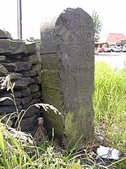
English: Guidestone, Lindley Moor Road / Crosland Road, Lindley cum Quarmby This was erected by A Mallinson, Surveyor, 1755. It was at a crossroads, and the directions for Lindley Moor Road are Brighouse III miles (why a Roman number?), Marsden 5 miles, and for the cross road Milsbridge 2 miles (via Crosland Road), Halifax 4 miles. The road to Halifax no longer exists; a track to Haigh House Hill is shown on the OS 6 map of c.1940, and from there a lane goes to Kew Hill. This track has now been severed by the M62. The cross road was not shown by Jeffreys on his map of 1775. W B Crump states in his book on Huddersfield Highways that the guidestone used to be in the middle of Crosland Road. |
| Date | |
| Source | From geograph.org.uk |
| Author | Humphrey Bolton |
| Attribution (required by the license) | Humphrey Bolton / Guidestone, Lindley Moor Road / Crosland Road, Lindley cum Quarmby / |
| Camera location | | View this and other nearby images on: OpenStreetMap |
|---|
_heading:270.00&language=en)
| Object location | | View this and other nearby images on: OpenStreetMap |
|---|
_heading:270.00&language=en)
Licensing

|
This image was taken from the Geograph project collection. See this photograph's page on the Geograph website for the photographer's contact details. The copyright on this image is owned by Humphrey Bolton and is licensed for reuse under the Creative Commons Attribution-ShareAlike 2.0 license.
|
This file is licensed under the Creative Commons Attribution-Share Alike 2.0 Generic license.
Attribution: Humphrey Bolton
- You are free:
- to share – to copy, distribute and transmit the work
- to remix – to adapt the work
- Under the following conditions:
- attribution – You must give appropriate credit, provide a link to the license, and indicate if changes were made. You may do so in any reasonable manner, but not in any way that suggests the licensor endorses you or your use.
- share alike – If you remix, transform, or build upon the material, you must distribute your contributions under the same or compatible license as the original.
File history
Click on a date/time to view the file as it appeared at that time.
| Date/Time | Thumbnail | Dimensions | User | Comment | |
|---|---|---|---|---|---|
| current | 22:23, 4 February 2011 | | 480 × 640 (113 KB) | GeographBot | == {{int:filedesc}} == {{Information |description={{en|1=Guidestone, Lindley Moor Road / Crosland Road, Lindley cum Quarmby This was erected by A Mallinson, Surveyor, 1755. It was at a crossroads, and the directions for Lindley Moor Road are Brighouse |
File usage
The following pages on the English Wikipedia use this file (pages on other projects are not listed):