Harry_McEntee_memorial_Finglas_2023.jpg (542 × 452 pixels, file size: 151 KB, MIME type: image/jpeg)
| This is a file from the Wikimedia Commons. Information from its description page there is shown below. Commons is a freely licensed media file repository. You can help. |
Summary
| DescriptionHarry McEntee memorial Finglas 2023.jpg |
English: Henry McEntee didn't support the Treaty, and became a captain in the re-organised Dublin IRA during Cogadh na gCarad (Ireland's Civil War).
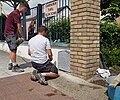
Whilst near his home on Gloucester Street (today Seán McDermott Street) on Tuesday the 31st July 1923 McEntee was abducted by members of the Criminal Investigation Department (CID). This counter-insurgency police unit had close links with National Army Intelligence and with the Protective Corps; all were based in Oriel House on Westland Row. On 3 August 1923 his body was found with a number of bullet wounds in a field at Maher’s farm, close to the Jamestown Road in Finglas in county Dublin. For more information on Henry McEntee and the activities of the Dublin IRA during Ireland's Civil War please see https://militarypensions.wordpress.com/2022/05/27/release-12-iras-dublin-brigade-active-service-unit-1922-23/ Henry MacEntee is interred in the Republican plot at Glasnevin Cemetery. A National Graves Association memorial plaque was placed there c.1932 and was maintained by the Fianna Sluagh in Finglas during the 1950's and 60's. Here Darren McGowan of Dublin Headstones is volunteering for the National Graves Association re-installing a cleaned memorial plaque ahead of the centenary of McEntee’s killing. |
| Date | |
| Source | Own work |
| Author | Cograng |
| Camera location | 53° 24′ 23″ N, 6° 17′ 40″ W | View this and other nearby images on: OpenStreetMap |
|---|
Licensing
- You are free:
- to share – to copy, distribute and transmit the work
- to remix – to adapt the work
- Under the following conditions:
- attribution – You must give appropriate credit, provide a link to the license, and indicate if changes were made. You may do so in any reasonable manner, but not in any way that suggests the licensor endorses you or your use.
- share alike – If you remix, transform, or build upon the material, you must distribute your contributions under the same or compatible license as the original.
Captions
Items portrayed in this file
depicts
21 June 2023
53°24'23.000"N, 6°17'39.998"W
0.00030266343825666 second
1.7
4.2 millimetre
File history
Click on a date/time to view the file as it appeared at that time.
| Date/Time | Thumbnail | Dimensions | User | Comment | |
|---|---|---|---|---|---|
| current | 15:00, 23 June 2023 |  | 542 × 452 (151 KB) | Cograng | Uploaded own work with UploadWizard |
File usage
The following page uses this file:
Metadata
This file contains additional information, probably added from the digital camera or scanner used to create or digitize it.
If the file has been modified from its original state, some details may not fully reflect the modified file.
| Camera manufacturer | samsung |
|---|---|
| Camera model | SM-G950F |
| Exposure time | 1/3,304 sec (0.00030266343825666) |
| F-number | f/1.7 |
| ISO speed rating | 40 |
| Date and time of data generation | 12:00, 21 June 2023 |
| Lens focal length | 4.2 mm |
| Latitude | 53° 24′ 23″ N |
| Longitude | 6° 17′ 40″ W |
| Altitude | 134 meters above sea level |
| Width | 2,709 px |
| Height | 2,260 px |
| Orientation | Normal |
| Horizontal resolution | 72 dpi |
| Vertical resolution | 72 dpi |
| Software used | G950FXXUCDVG4 |
| File change date and time | 12:42, 21 June 2023 |
| Y and C positioning | Centered |
| Exposure Program | Normal program |
| Exif version | 2.2 |
| Date and time of digitizing | 12:00, 21 June 2023 |
| Meaning of each component |
|
| Shutter speed | 11.69 |
| APEX aperture | 1.53 |
| APEX brightness | 9.41 |
| Exposure bias | 0 |
| Maximum land aperture | 1.53 APEX (f/1.7) |
| Metering mode | Center weighted average |
| Light source | Unknown |
| Flash | Flash did not fire |
| DateTime subseconds | 0870 |
| DateTimeOriginal subseconds | 0870 |
| DateTimeDigitized subseconds | 0870 |
| Supported Flashpix version | 1 |
| Color space | sRGB |
| Scene type | A directly photographed image |
| Exposure mode | Auto exposure |
| White balance | Auto white balance |
| Focal length in 35 mm film | 26 mm |
| Scene capture type | Standard |
| Contrast | Normal |
| Saturation | Normal |
| Sharpness | Normal |
| Unique image ID | F12LLJA00VM F12LLKL01GM |
| GPS time (atomic clock) | 11:00 |
| GPS date | 21 June 2023 |
| GPS tag version | 2.2.0.0 |
