
Size of this preview: 457 × 599 pixels. Other resolutions: 183 × 240 pixels | 366 × 480 pixels | 585 × 768 pixels | 781 × 1,024 pixels | 1,561 × 2,048 pixels | 2,676 × 3,510 pixels.
Original file (2,676 × 3,510 pixels, file size: 2.36 MB, MIME type: image/jpeg)
| This is a file from the Wikimedia Commons. Information from its description page there is shown below. Commons is a freely licensed media file repository. You can help. |
Summary
| Description |
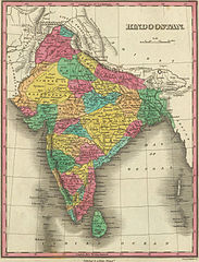
Map of Hindostan or India (1831) by Anthony Finley |
|||||||||
| Date | ||||||||||
| Source | David Rumsey Collection of Historic Maps The link to the source is here | |||||||||
| Creator |
Anthony Finley |
|||||||||
| Geotemporal data | ||||||||||
| Bounding box |
|
|||||||||
| Georeferencing | ||||||||||
Licensing
|
This work is in the public domain in its country of origin and other countries and areas where the copyright term is the author's life plus 70 years or fewer. | |
| This file has been identified as being free of known restrictions under copyright law, including all related and neighboring rights. | |
|
This work is in the public domain in its country of origin and other countries and areas where the copyright term is the author's life plus 100 years or fewer. This work is in the public domain in the United States because it was published (or registered with the U.S. Copyright Office) before January 1, 1929. | |
| This file has been identified as being free of known restrictions under copyright law, including all related and neighboring rights. | |
File history
Click on a date/time to view the file as it appeared at that time.
| Date/Time | Thumbnail | Dimensions | User | Comment | |
|---|---|---|---|---|---|
| current | 15:30, 30 March 2007 | | 2,676 × 3,510 (2.36 MB) | Planemad | ==Description== * Map of Hindostan or India (1831) by Anthony Finley from the [http://www.davidrumsey.com/ David Rumsey Collection of Historic Maps] ==Source== http://recall.curtin.edu.au/ecai/historic%20maps.htm ==License== {{cc-by-sa 2.0}} {{PD-old}} |
File usage
The following pages on the English Wikipedia use this file (pages on other projects are not listed):
Global file usage
The following other wikis use this file:
- Usage on be-tarask.wikipedia.org
- Usage on de.wikipedia.org
- Usage on el.wikipedia.org
- Usage on fa.wikipedia.org
- Usage on ja.wikipedia.org
- Usage on ko.wikipedia.org
- Usage on lt.wikipedia.org
- Usage on pnb.wikipedia.org
- Usage on ps.wikipedia.org
- Usage on ur.wikipedia.org
- Usage on vi.wikipedia.org