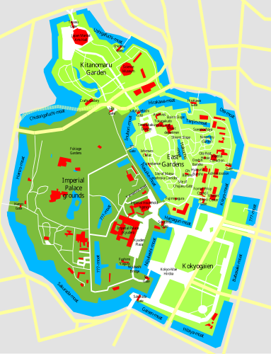
Size of this PNG preview of this SVG file: 383 × 500 pixels. Other resolutions: 184 × 240 pixels | 368 × 480 pixels | 588 × 768 pixels | 784 × 1,024 pixels | 1,569 × 2,048 pixels.
Original file (SVG file, nominally 383 × 500 pixels, file size: 384 KB)
File history
Click on a date/time to view the file as it appeared at that time.
| Date/Time | Thumbnail | Dimensions | User | Comment | |
|---|---|---|---|---|---|
| current | 00:43, 21 November 2009 |  | 383 × 500 (384 KB) | Justass | cropped |
| 00:40, 21 November 2009 |  | 500 × 500 (384 KB) | Justass | ? | |
| 00:20, 21 November 2009 |  | 512 × 668 (361 KB) | ExplicitImplicity | {{Information |Description=This is the SVG version of Image:Imperial Palace Tokyo Map.sxd, checked with a GoogleMaps Satellite Image and corrected for proportions. Notes by the original authoru: This is a map of the Imperial Palace in Tokyo (Kokyo |
File usage
The following page uses this file:
Global file usage
The following other wikis use this file:
- Usage on ca.wikipedia.org
- Usage on de.wikipedia.org
- Usage on fr.wikipedia.org
- Usage on it.wikipedia.org
- Usage on it.wikivoyage.org
- Usage on ms.wikipedia.org
- Usage on ru.wikipedia.org
- Usage on simple.wikipedia.org
- Usage on sv.wikipedia.org
- Usage on www.wikidata.org
