Size of this preview: 526 × 600 pixels. Other resolutions: 210 × 240 pixels | 421 × 480 pixels | 642 × 732 pixels.
Original file (642 × 732 pixels, file size: 138 KB, MIME type: image/jpeg)
| This is a file from the Wikimedia Commons. Information from its description page there is shown below. Commons is a freely licensed media file repository. You can help. |

|
File:Iran Air Flight 655 map.svg is a vector version of this file. It should be used in place of this JPG file when not inferior.
File:Iran Air 655 Strait of hormuz.jpg → File:Iran Air Flight 655 map.svg
For more information, see Help:SVG.
|
Summary
| DescriptionIran Air 655 Strait of hormuz.jpg |
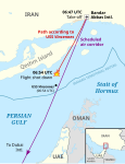
English: Derivative map showing intended route of Iran Air 655 and approximate location of downing.
Basemap description:A crop of the Map of Persia (by George Curzon) showing the Strait of Hormuz - 1892 - The Royal Geographical Society (with the Institute of British Geographers). location based on: Iran Air 655 ... the missiles impacted approximately 8 miles from Vincennes; the plane crashed into the Persian Gulf 6.5 miles east of Hengham Island (26°37.75′N 56°1′E / 26.62917°N 56.017°E / 26.62917; 56.017). فارسی: نقشهٔ اشتقاقی که مسیر طرحریزی شده برای پرواز شماره ۶۵۵ ایران ایر و محل تقریبی سرنگونی آن را نشان میدهد. توضیحات نقشهٔ مبنا: برشی از نقشهٔ ایران (توسط جورج کرزن) که تنگهٔ هرمز را نمایش میدهد - ۱۸۹۲- انجمن سلطنتی جغرافیایی (همراه با مؤسسهٔ جغرافیدانان بریتانیا). اساس موقعیت: پرواز شماره ۶۵۵ ایران ایر ... موشکها تقریباً در هشت کیلومتری وینسنس به هدف اصابت کردند؛ هواپیما در خلیج فارس و در ۶٬۵ مایلی شرق جزیره هنگام سقوط کرد. |
||||||||||||||||||||||||||
| Date | Basemap, 1892 | ||||||||||||||||||||||||||
| Source | Own work | ||||||||||||||||||||||||||
| Author |
creator QS:P170,Q271878 |
||||||||||||||||||||||||||
| Other versions | Based on Image:Strait of hormuz.jpg | ||||||||||||||||||||||||||
Basemap license
| Public domainPublic domainfalsefalse |
|
This work is in the public domain in its country of origin and other countries and areas where the copyright term is the author's life plus 70 years or fewer. Note that a few countries have copyright terms longer than 70 years: Mexico has 100 years, Jamaica has 95 years, Colombia has 80 years, and Guatemala and Samoa have 75 years. This image may not be in the public domain in these countries, which moreover do not implement the rule of the shorter term. Honduras has a general copyright term of 75 years, but it does implement the rule of the shorter term. Copyright may extend on works created by French who died for France in World War II (more information), Russians who served in the Eastern Front of World War II (known as the Great Patriotic War in Russia) and posthumously rehabilitated victims of Soviet repressions (more information).
| |
| This file has been identified as being free of known restrictions under copyright law, including all related and neighboring rights. | |
https://creativecommons.org/publicdomain/mark/1.0/PDMCreative Commons Public Domain Mark 1.0falsefalse
Licensing
I, the copyright holder of this work, hereby publish it under the following licenses:

|
Permission is granted to copy, distribute and/or modify this document under the terms of the GNU Free Documentation License, Version 1.2 or any later version published by the Free Software Foundation; with no Invariant Sections, no Front-Cover Texts, and no Back-Cover Texts. A copy of the license is included in the section entitled GNU Free Documentation License.http://www.gnu.org/copyleft/fdl.htmlGFDLGNU Free Documentation Licensetruetrue |
| This file is licensed under the Creative Commons Attribution-Share Alike 3.0 Unported license. | ||
| ||
| This licensing tag was added to this file as part of the GFDL licensing update.http://creativecommons.org/licenses/by-sa/3.0/CC BY-SA 3.0Creative Commons Attribution-Share Alike 3.0truetrue |
You may select the license of your choice.
Captions
Add a one-line explanation of what this file represents
Items portrayed in this file
depicts
File history
Click on a date/time to view the file as it appeared at that time.
| Date/Time | Thumbnail | Dimensions | User | Comment | |
|---|---|---|---|---|---|
| current | 23:25, 7 November 2007 |  | 642 × 732 (138 KB) | Dual Freq | {{Information |Description=Derivative map showing intended route of Iran Air 655 and approximate location of downing. Basemap description:A crop of the Map of Persia (by George Curzon) showing the Strait of Hormuz - 1892 - The Royal Geographical Society ( |
File usage
The following page uses this file:
Retrieved from "https://en.wikipedia.org/wiki/File:Iran_Air_655_Strait_of_hormuz.jpg"

