Size of this preview: 712 × 600 pixels. Other resolutions: 285 × 240 pixels | 570 × 480 pixels | 912 × 768 pixels | 1,215 × 1,024 pixels | 1,728 × 1,456 pixels.
Original file (1,728 × 1,456 pixels, file size: 2.67 MB, MIME type: image/jpeg)
| This is a file from the Wikimedia Commons. Information from its description page there is shown below. Commons is a freely licensed media file repository. You can help. |
Summary
| Description |
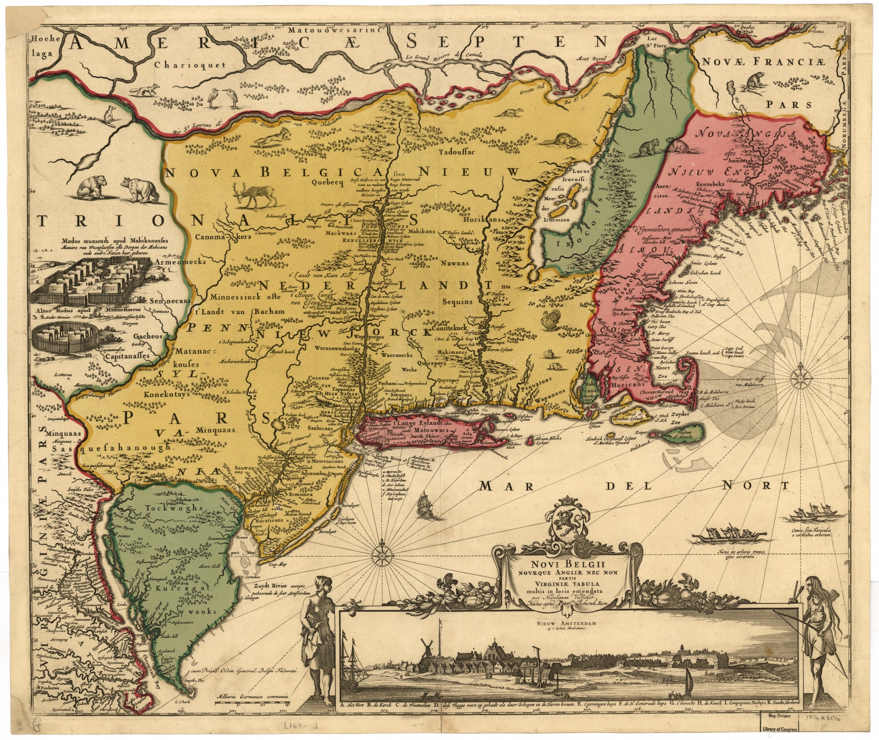
Nederlands: De Jansson-Visscher kaart van Nieuw Nederland, eerste uitgave 1650. Links afbeeldingen van Indiaanse dorpen, rechts onder een visoog profiel van de stad Nieuw Amsterdam. Deze kaart is een latere ingekleurde versie die latere grenzen met Nieuw Engeland weergeeft. Zie ook Image:Map-Novi Belgii Novæque Angliæ (Amsterdam, 1685).jpg.
Legenda: English: The Jansson-Visscher map of New Netherland, first published in 1650. On the left are illustrations of typical Indian villages, while the lower right inset shows a picture of New Amsterdam. This copy is a later recoloration to reflect later borders with New England. See also Image:Map-Novi Belgii Novæque Angliæ (Amsterdam, 1685).jpg.
Legend in Dutch: Español: El mapa Jansson-Visscher del noreste de América, publicado por primera vez por Van der Donck |
||
| Date | |||
| Source |
|
||
| Author | Nicolaus Visscher (Novi Belgii Novaeque Angliae Nec Non Pennsylvaniae et Partis Virginiae Tabula multis in locis emendate per Nicolaum Visscher nunc apud Peter Schenk Iun:) | ||
| Other versions |
|


.jpg)

.jpg)


.png)
Licensing
|
This work is in the public domain in its country of origin and other countries and areas where the copyright term is the author's life plus 100 years or fewer. This work is in the public domain in the United States because it was published (or registered with the U.S. Copyright Office) before January 1, 1929. | |
| This file has been identified as being free of known restrictions under copyright law, including all related and neighboring rights. | |
File history
Click on a date/time to view the file as it appeared at that time.
| Date/Time | Thumbnail | Dimensions | User | Comment | |
|---|---|---|---|---|---|
| current | 14:07, 15 April 2018 | | 1,728 × 1,456 (2.67 MB) | Hansmuller | Reverted to version as of 12:50, 30 July 2012 (UTC) |
| 12:57, 30 July 2012 |  | 496 × 418 (69 KB) | Joopr132 | Reverted to version as of 15:38, 3 December 2005 | |
| 12:50, 30 July 2012 |  | 1,728 × 1,456 (2.67 MB) | Joopr132 | Higher Resolution | |
| 15:38, 3 December 2005 |  | 496 × 418 (69 KB) | Laurascudder | The Jansson-Visscher map of en:New Netherland, first published in 1650. On the left are illustrations of typical indian villiages of several types, while the lower right inset shows a picture of New Amsterdam. See also [[:Image:Map-Novi Belgii Novæ |
File usage
The following pages on the English Wikipedia use this file (pages on other projects are not listed):
Global file usage
The following other wikis use this file:
- Usage on azb.wikipedia.org