
Size of this preview: 553 × 599 pixels. Other resolutions: 221 × 240 pixels | 443 × 480 pixels | 709 × 768 pixels | 945 × 1,024 pixels | 1,890 × 2,048 pixels | 3,600 × 3,900 pixels.
Original file (3,600 × 3,900 pixels, file size: 2.42 MB, MIME type: image/jpeg)
| This is a file from the Wikimedia Commons. Information from its description page there is shown below. Commons is a freely licensed media file repository. You can help. |
| Description |
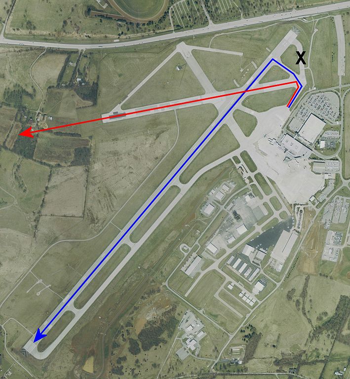
USGS urban ortho of Blue Grass Airport, Kentucky, USA. Overlayed with intended route vs actual route and approx crash site. X denotes the taxiway that was closed following recent construction. Desired path via Rwy 22 Actual path via Rwy 26, ending at approximate crash site. X marks the closed taxiway |
|||
| Date | Base map, April 2, 2002 | |||
| Source | Extracted via USA Photomaps software | |||
| Author | Path data is approximate and was overlayed by Dual Freq on top of PD original. | |||
| Permission (Reusing this file) |
|
|||
| Other versions | Image:KLEX Blue Grass Airport.jpg Full sized original |
File history
Click on a date/time to view the file as it appeared at that time.
| Date/Time | Thumbnail | Dimensions | User | Comment | |
|---|---|---|---|---|---|
| current | 23:45, 29 August 2006 | | 3,600 × 3,900 (2.42 MB) | Dual Freq | Revised to show larger lines and full length of 22 |
| 20:40, 29 August 2006 |  | 3,800 × 2,600 (1.7 MB) | Dual Freq | {{Information |Description=USGS urban ortho of Blue Grass Airport, Kentucky, USA. Overlayed with intended route vs actual route and approx crash site. |Source=Extracted via USA Photomaps software |Date=B |
File usage
The following 4 pages use this file:
Global file usage
The following other wikis use this file:
- Usage on ar.wikipedia.org
- Usage on de.wikipedia.org
- Usage on en.wikinews.org
- Usage on es.wikipedia.org
- Usage on fr.wikipedia.org
- Usage on it.wikipedia.org
- Usage on ja.wikipedia.org
- Usage on pl.wikipedia.org
- Usage on ru.wikipedia.org
- Usage on sv.wikipedia.org