Size of this preview: 523 × 600 pixels. Other resolutions: 209 × 240 pixels | 600 × 688 pixels.
Original file (600 × 688 pixels, file size: 364 KB, MIME type: image/png)
File history
Click on a date/time to view the file as it appeared at that time.
| Date/Time | Thumbnail | Dimensions | User | Comment | |
|---|---|---|---|---|---|
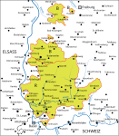
| current | 11:44, 17 September 2006 |  | 600 × 688 (364 KB) | Roadytom~commonswiki | Karte der Markgrafschaft, im Bild graue Fläche, nach 1556 nach dem Zukauf der ehemals vorderösterreichen Gemeinde Gersbach im Wiesental, Roadytom, nach einer alten Vorlage selbst gezeichnet. |
File usage
No pages on the English Wikipedia use this file (pages on other projects are not listed).


