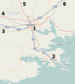
LA2_Nyköping_surrounding.png (534 × 598 pixels, file size: 26 KB, MIME type: image/png)
File history
Click on a date/time to view the file as it appeared at that time.
| Date/Time | Thumbnail | Dimensions | User | Comment | |
|---|---|---|---|---|---|
| current | 03:24, 9 October 2009 |  | 534 × 598 (26 KB) | LA2 | {{Information |Description={{en|1=Map of the surroundings of Nyköping, showing (1) Nyköping, (2) Oxelösund, (3) motorway E4 and railroad towards Norrköping and Malmö, (4) road 52 and railroad towards Katrineholm and Kumla, (5) road 53 towards Malmkö |
File usage
The following page uses this file:
Global file usage
The following other wikis use this file:
- Usage on de.wiktionary.org
- Usage on gd.wikipedia.org
- Usage on io.wikipedia.org

