
Size of this PNG preview of this SVG file: 537 × 599 pixels. Other resolutions: 215 × 240 pixels | 430 × 480 pixels | 688 × 768 pixels | 918 × 1,024 pixels | 1,836 × 2,048 pixels | 650 × 725 pixels.
Original file (SVG file, nominally 650 × 725 pixels, file size: 56 KB)
| This is a file from the Wikimedia Commons. Information from its description page there is shown below. Commons is a freely licensed media file repository. You can help. |
Summary
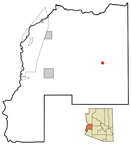
| Description | This map shows the incorporated areas and unincorporated areas in La Paz County, Arizona. Salome is highlighted in red. Incorporated cities are shown in gray and unincorporated communities or CDPs are shown in white. Data for the borders and locations are based on maps from the La Paz County Public Works - Comprehensive Plan 2005, US Census Bureau TIGER Map Server, and ITCA Map of Tribal Homelands in Arizona. I created this map in Inkscape. |
| Date | |
| Source | My own work, based on public domain information |
| Author | Ixnayonthetimmay |
| Permission (Reusing this file) |
All rights not reserved. See below. |
| Other versions | See Category:Maps of La Paz County for other versions of this image. |
Licensing
| I, the copyright holder of this work, release this work into the public domain. This applies worldwide. In some countries this may not be legally possible; if so: I grant anyone the right to use this work for any purpose, without any conditions, unless such conditions are required by law. |
File history
Click on a date/time to view the file as it appeared at that time.
| Date/Time | Thumbnail | Dimensions | User | Comment | |
|---|---|---|---|---|---|
| current | 17:50, 23 March 2007 | | 650 × 725 (56 KB) | Ixnayonthetimmay | {{Information |Description=This map shows the incorporated areas and unincorporated areas in La Paz County, Arizona. Salome is highligh |
File usage
The following page uses this file:
Global file usage
The following other wikis use this file:
- Usage on ar.wikipedia.org
- Usage on arz.wikipedia.org
- Usage on azb.wikipedia.org
- Usage on ca.wikipedia.org
- Usage on de.wikipedia.org
- Usage on eu.wikipedia.org
- Usage on fa.wikipedia.org
- Usage on fr.wikipedia.org
- Usage on ht.wikipedia.org
- Usage on it.wikipedia.org
- Usage on sr.wikipedia.org
- Usage on tt.wikipedia.org
- Usage on www.wikidata.org