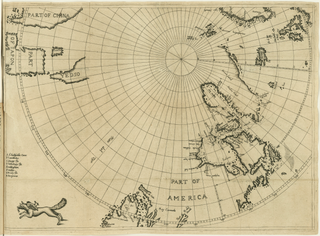
English: Fold-out engraved map from
Luke Foxe's voyage account book, showing the route of his 1631 sea expedition from England (top right) in search of a Northwest passage towards Asia (top left) through Hudson Strait, exploring Hudson Bay and Foxe Basin (
detail). The map uses the
azimuthal equidistant projection, with the North Pole as its center point. At bottom left, near the
Island of California, the map is decorated with a
fox, the author's emblem.
I have also placed a Polar Map or Card, that this Discoverie may be the better understood, and for that I did desire to give satisfaction by Demonstration of all treated of in the Booke, for otherwise, another projection could not have contained it but at unreasonable diversity; and because I cannont describe all the Names in Fretum Hudson, of Capes, Ilands, and Bayes at length in Letters, in respect of the smalnesse of the Degrees of Longitude, I have inserted them in a table by the letters of the Alphabet, as thou shalt find, beginning with A, b, c, d, and tracted my owne way and discovery foorth and home, in small prickles.

.svg)


_-_3_foldout_map_-_2_Hudson_Bay.png)
_-_4_foldout_map_-_3_fox.png)
_-_2_foldout_map_-1_full_view.png)
_-_2_foldout_map_-1_full_view.png&action=edit&redlink=1)
_-_2_foldout_map_-1_full_view.png)
_-_2_foldout_map_-1_full_view.png)