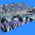
MPP_stereo_analysis.jpg (512 × 512 pixels, file size: 40 KB, MIME type: image/jpeg)
File history
Click on a date/time to view the file as it appeared at that time.
| Date/Time | Thumbnail | Dimensions | User | Comment | |
|---|---|---|---|---|---|
| current | 14:57, 24 January 2007 |  | 512 × 512 (40 KB) | Davepape | {{Information |Description=Computer rendering of a topographic map of the Camargo Syncline in Bolivia. The topographic data was generated by a stereo analysis algorithm developed by Jim Strong (NASA/GSFC) for the {{w|Goodyear MPP}} (Massively Parallel Pro |
File usage
The following page uses this file:
Global file usage
The following other wikis use this file:
- Usage on it.wikipedia.org
- Usage on www.wikidata.org


