
Size of this preview: 558 × 600 pixels. Other resolutions: 223 × 240 pixels | 447 × 480 pixels | 715 × 768 pixels | 1,084 × 1,165 pixels.
Original file (1,084 × 1,165 pixels, file size: 264 KB, MIME type: image/png)
| This is a file from the Wikimedia Commons. Information from its description page there is shown below. Commons is a freely licensed media file repository. You can help. |
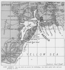
Map of Port Arthur
from JANE'S FIGHTING SHIPS 1906-07, Edited by Fred T. Jane, Published by Sampson Low, Marston, 1906
Modified by user:Ideru
|
This work is in the public domain in its country of origin and other countries and areas where the copyright term is the author's life plus 70 years or fewer. | |
| This file has been identified as being free of known restrictions under copyright law, including all related and neighboring rights. | |
File history
Click on a date/time to view the file as it appeared at that time.
| Date/Time | Thumbnail | Dimensions | User | Comment | |
|---|---|---|---|---|---|
| current | 06:07, 30 April 2006 | | 1,084 × 1,165 (264 KB) | Ideru~commonswiki | Map of Port Arthur from ''JANE'S FIGHTING SHIPS 1906-07'', Edited by Fred T. Jane, Published by Sampson Low, Marston, 1906 Modified by user:Ideru {{PDold}} |
File usage
The following pages on the English Wikipedia use this file (pages on other projects are not listed):
Global file usage
The following other wikis use this file:
- Usage on ca.wikipedia.org
- Usage on da.wikipedia.org
- Usage on es.wikipedia.org
- Usage on fr.wikipedia.org
- Usage on it.wikipedia.org
- Usage on ja.wikipedia.org
- Usage on ro.wikipedia.org
- Usage on zh.wikipedia.org