No higher resolution available.
Map_of_USA_highlighting_Sun_Belt.png (280 × 183 pixels, file size: 40 KB, MIME type: image/png)
| This is a file from the Wikimedia Commons. Information from its description page there is shown below. Commons is a freely licensed media file repository. You can help. |
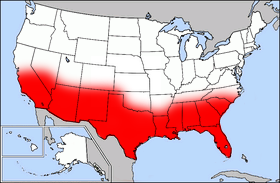
Public domain map courtesy of The General Libraries, The University of Texas at Austin, modified (by • Benc • 00:36, 13 Aug 2004 (UTC) to highlight regions.
Originally uploaded onto English Wikipedia 00:36, 13 August 2004 by Benc
English: This map come from the map collection of University of Texas, specifically from: [{{{url}}} {{{title}}}, from {{{origin}}}]. It is in the public domain (http://www.lib.utexas.edu/maps/faq.html#3.html).
Français : Cette carte est issue issu de la collection de cartes de l'université du Texas et plus précisément de celle-ci : [{{{url}}} {{{title}}}, from {{{origin}}}]. Elle se trouve dans dans le domaine public (http://www.lib.utexas.edu/maps/faq.html#3.html).
Nederlands: Deze afbeelding is afkomstig uit de kaartencollectie van de University of Texas. Deze kaarten bevinden zich in het publiek domein (http://www.lib.utexas.edu/maps/faq.html#3.html).
|
|
This work is in the public domain in its country of origin and other countries and areas where the copyright term is the author's life plus 70 years or fewer. | |
| This file has been identified as being free of known restrictions under copyright law, including all related and neighboring rights. | |
File history
Click on a date/time to view the file as it appeared at that time.
| Date/Time | Thumbnail | Dimensions | User | Comment | |
|---|---|---|---|---|---|
| current | 17:41, 27 September 2006 | | 280 × 183 (40 KB) | Mr Bullitt~commonswiki | Public domain map courtesy of [http://www.lib.utexas.edu/ The General Libraries, The University of Texas at Austin], modified (by • Benc • 00:36, 13 Aug 2004 (UTC)) to highlight regions. Originally uploaded |
File usage
The following pages on the English Wikipedia use this file (pages on other projects are not listed):
Global file usage
The following other wikis use this file:
- Usage on fr.wikipedia.org