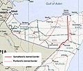
Map_of_somaliland_border_claims.jpg (590 × 504 pixels, file size: 118 KB, MIME type: image/jpeg)
File history
Click on a date/time to view the file as it appeared at that time.
| Date/Time | Thumbnail | Dimensions | User | Comment | |
|---|---|---|---|---|---|
| current | 17:16, 19 October 2023 |  | 590 × 504 (118 KB) | Maantadhabtiye | https://horseedmedia.net/somali-federal-government-recognizes-new-ssc-khatumo-administration-383891 |
| 18:37, 20 June 2020 |  | 590 × 504 (241 KB) | Kzl55 | Reverted to version as of 12:41, 23 November 2018 (UTC) Map based on Markus Hoehne's work Between Somaliland and Puntland (Contested Borderlands), 2015. | |
| 15:55, 17 June 2020 |  | 590 × 504 (115 KB) | Meelpringthusss | Puntland's proclaimed borders per official government release - http://mediapuntland.org/puntland-map-calls-for-peace-and-respect-for-sacredness-of-human-life-amid-tensions-in-sool-region/ | |
| 12:41, 23 November 2018 |  | 590 × 504 (241 KB) | Kzl55 | Updated based on Markus Hoehne's map in Between Somaliland and Puntland (Contested Borderlands), 2015. | |
| 19:49, 19 October 2007 |  | 506 × 586 (167 KB) | Béka~commonswiki | {{Information |Description=Map of Somaliland border dispute as of August, 2007. Modification of Image:Somalia pol02.jpg fro Wikimedia Commons. en:Category:Maps of Somalia en:Category:PD tag needs updating |Source=Originally from [http://en.wi |
File usage
No pages on the English Wikipedia use this file (pages on other projects are not listed).
Global file usage
The following other wikis use this file:
- Usage on ast.wikipedia.org
- Usage on cs.wikipedia.org
- Usage on en.wikibooks.org
- Usage on eo.wikipedia.org
- Usage on es.wikipedia.org
- Usage on fr.wikipedia.org
- Usage on gl.wikipedia.org
- Usage on it.wikipedia.org
- Usage on ja.wikipedia.org
- Usage on ml.wikipedia.org
- Usage on pt.wikipedia.org
- Usage on ru.wikipedia.org
- Usage on uk.wikipedia.org
- Usage on zh.wikipedia.org


