No higher resolution available.
Maudland_Bridge_station.jpg (640 × 371 pixels, file size: 30 KB, MIME type: image/jpeg)
| This is a file from the Wikimedia Commons. Information from its description page there is shown below. Commons is a freely licensed media file repository. You can help. |
Summary
| Description |
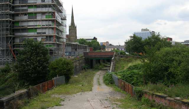
English: View from Maudland Bridge The site of the disused Lancaster Canal goes horizontally across the middle of the shot. The tracks of a disused railway can also be seen. From 1856 to 1885 this was the site of Maudlands Bridge railway station, the terminus of a railway line to Longridge. The line closed to passengers in 1930 but continued to be used for goods until the 1990s. |
| Date | |
| Source | From geograph.org.uk |
| Author | Betty Longbottom |
| Permission (Reusing this file) |
Creative Commons Attribution Share-alike license 2.0 |
| Attribution (required by the license) | Betty Longbottom / View from Maudland Bridge / |
| Camera location | | View this and other nearby images on: OpenStreetMap |
|---|
_heading:45.00&language=en)
| Object location | | View this and other nearby images on: OpenStreetMap |
|---|
_heading:45.00&language=en)
Licensing

|
This image was taken from the Geograph project collection. See this photograph's page on the Geograph website for the photographer's contact details. The copyright on this image is owned by Betty Longbottom and is licensed for reuse under the Creative Commons Attribution-ShareAlike 2.0 license.
|
This file is licensed under the Creative Commons Attribution-Share Alike 2.0 Generic license.
Attribution: Betty Longbottom
- You are free:
- to share – to copy, distribute and transmit the work
- to remix – to adapt the work
- Under the following conditions:
- attribution – You must give appropriate credit, provide a link to the license, and indicate if changes were made. You may do so in any reasonable manner, but not in any way that suggests the licensor endorses you or your use.
- share alike – If you remix, transform, or build upon the material, you must distribute your contributions under the same or compatible license as the original.
File history
Click on a date/time to view the file as it appeared at that time.
| Date/Time | Thumbnail | Dimensions | User | Comment | |
|---|---|---|---|---|---|
| current | 17:15, 25 September 2007 | | 640 × 371 (30 KB) | Dr Greg | {{Information |Description={{en|Site of former Maudland Bridge railway station in Preston, Lancashire, England}} |Source=[http://www.geograph.org.uk/photo/529161 Geograph project] |Date=2007-08-12 |Author=Betty Longbottom |Permission={{geograph|529161|B |
File usage
The following 2 pages use this file:
Global file usage
The following other wikis use this file:
- Usage on www.wikidata.org