Original file (2,100 × 1,525 pixels, file size: 129 KB, MIME type: image/png)

File:EU27-2008-Union for the Mediterranean.svg is a vector version of this file. It should be used in place of this PNG file when not inferior.


For more information, see Help:SVG.

In other languages
Alemannisch  العربية  беларуская (тарашкевіца)  български  বাংলা  català  нохчийн  čeština  dansk  Deutsch  Ελληνικά  English  British English  Esperanto  español  eesti  euskara  فارسی  suomi  français  Frysk  galego  Alemannisch  עברית  hrvatski  magyar  հայերեն  Bahasa Indonesia  Ido  italiano  日本語  ქართული  한국어  lietuvių  македонски  മലയാളം  Bahasa Melayu  norsk bokmål  Plattdüütsch  Nederlands  norsk nynorsk  norsk  occitan  polski  prūsiskan  português  português do Brasil  română  русский  sicilianu  Scots  slovenčina  slovenščina  српски / srpski  svenska  தமிழ்  ไทย  Türkçe  татарча / tatarça  українська  vèneto  Tiếng Việt  中文  中文(中国大陆)  中文(简体)  中文(繁體)  中文(马来西亚)  中文(新加坡)  中文(臺灣)  中文(臺灣)  +/−
New SVG image

Summary

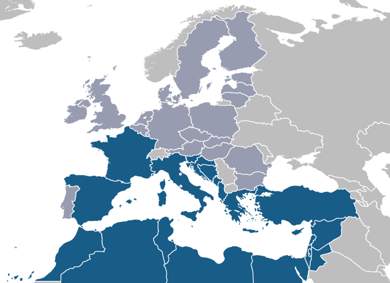
Català: Unió Mediterrània. Possibles candidats a la Unió Mediterrània (blau) amb la resta de la Unió Europea (gris fosc).
Deutsch: Diagramm der von Nicolas Sarkozy vorgeschlagenen Mittelmeerunion. Meine Arbeit, angepasst von einem allgemeinen Bild auf wikicommons: Image:BlankMap-Europe-v4.png
English: Map of Sarkozy's proposed Mediterranean Union. Own work, adapted from a public image on wikicommons: Image:BlankMap-Europe-v4.png. Possible membership of the Mediterranean Union (blue) with the rest of the European Union (dark grey).
Ελληνικά: Μεσογειακή ένωση
Español: Mapa de la Unión Mediterránea propuesta por Sarkozy, adaptado de una imagen pública en wikicommons: Image:BlankMap-Europe-v4.png.
Français : Carte de l'union méditerranéenne proposée de Sarkozy's. Mon travail, adapté d'une image publique sur wikicommons: Image:BlankMap-Europe-v4.png. Membres éventuels de l’Union méditerranéenne (en bleu), avec le reste de l’Union européenne (gris foncé).
Italiano: Programma dell'unione mediterranea proposta da Sarkozy. Il mio lavoro, adattato da un'immagine pubblica sui wikicommons: Image:BlankMap-Europe-v4.png. Possibili stati membri dell'Unione Mediterranea (blu) con il resto dell'Unione Europea (grigio scuro).
Nederlands: Kaart van Sarkozy's Mediterrane Unie die van een openbaar beeld op wikicommons wordt aangepast: Image:BlankMap-Europe-v4.png. Mogelijk lidmaatschap van de Mediterrane Unie (blauw) met de rest van de Europese Unie (donkergrijs)
Português: Mapa da União Mediterrânica proposta de Sarkozy's. Meu trabalho, adaptado de uma imagem pública em wikicommons: Image:BlankMap-Europe-v4.png. Membros previsíveis da União Mediterrânica (azul). A cinzento escuro os restantes membros da União Europeia.
Türkçe: Akdeniz Birliği
Русский: Предполагаемые участники Средиземноморсого союза;

Средиземноморские страны(синий) Страны-члены ЕС(светло-серый)

Licensing

Public domain I, the copyright holder of this work, release this work into the public domain. This applies worldwide.
In some countries this may not be legally possible; if so:
I grant anyone the right to use this work for any purpose, without any conditions, unless such conditions are required by law.

Captions

Add a one-line explanation of what this file represents

Items portrayed in this file

depicts

File history

Click on a date/time to view the file as it appeared at that time.

Date/TimeThumbnailDimensionsUserComment
current16:10, 23 May 2008Thumbnail for version as of 16:10, 23 May 20082,100 × 1,525 (129 KB)Nightstallionlatest proposal foresees all neighbour countries as part
09:18, 16 March 2008Thumbnail for version as of 09:18, 16 March 20082,100 × 1,525 (120 KB)J. Patrick FischerSlovenija has a coast to Med.
11:10, 14 March 2008Thumbnail for version as of 11:10, 14 March 20082,100 × 1,525 (44 KB)J. Patrick FischerPortugal is not bordering the Mediteranian Sea
22:48, 18 January 2008Thumbnail for version as of 22:48, 18 January 20082,100 × 1,525 (60 KB)JLoganchanged ministates from EU dark grey to light grey and added Pal.
09:35, 24 August 2007Thumbnail for version as of 09:35, 24 August 20072,100 × 1,525 (43 KB)Roke~commonswiki
09:22, 24 August 2007Thumbnail for version as of 09:22, 24 August 20072,100 × 1,525 (132 KB)Roke~commonswikifix low countries
10:04, 17 August 2007Thumbnail for version as of 10:04, 17 August 20072,100 × 1,525 (75 KB)Roke~commonswikibetter base map, same colours
21:34, 16 April 2007Thumbnail for version as of 21:34, 16 April 2007534 × 534 (15 KB)JLoganMap of Sarkozy's proposed Mediterranean Union. Own work, adapted from from public image on wikicommons: Image:Euro-med.png
No pages on the English Wikipedia use this file (pages on other projects are not listed).

Global file usage

The following other wikis use this file: