Size of this preview: 659 × 600 pixels. Other resolutions: 264 × 240 pixels | 527 × 480 pixels | 844 × 768 pixels | 1,160 × 1,056 pixels.
Original file (1,160 × 1,056 pixels, file size: 64 KB, MIME type: image/png)
File history
Click on a date/time to view the file as it appeared at that time.
| Date/Time | Thumbnail | Dimensions | User | Comment | |
|---|---|---|---|---|---|
| current | 21:00, 31 March 2016 |  | 1,160 × 1,056 (64 KB) | Fry1989 | Reverted to version as of 20:09, 23 February 2011 (UTC) |
| 20:39, 14 November 2015 |  | 1,160 × 1,056 (30 KB) | Hpyounes | Reverted to version as of 11:42, 21 March 2010 (UTC) | |
| 20:39, 14 November 2015 |  | 1,160 × 1,056 (30 KB) | Hpyounes | Reverted to version as of 11:42, 21 March 2010 (UTC) | |
| 20:09, 23 February 2011 |  | 1,160 × 1,056 (64 KB) | Omar-Toons | Neutral, more appropriate version for the "bilateral relations" Template | |
| 17:56, 6 May 2010 |  | 1,160 × 1,056 (52 KB) | Roxanna | Morocco de jure without Western Sahara | |
| 11:42, 21 March 2010 |  | 1,160 × 1,056 (30 KB) | Roxanna | detailed, colours changed | |
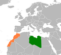
| 11:22, 21 March 2010 |  | 467 × 486 (33 KB) | Roxanna | {{Information |Description={{en|1=Morocco (green, including Western Sahara) & Libya (orange) locator map}} |Source=based on Image:BlankMap-Africa.png |Author=Own work |Date=21-03-2010 |Permission=See below |other_versions= }} |
File usage
The following 2 pages use this file:
Global file usage
The following other wikis use this file:
- Usage on ar.wikipedia.org
- Usage on de.wikipedia.org
- Usage on fa.wikipedia.org
- Usage on he.wikipedia.org
- Usage on ru.wikipedia.org
- Usage on www.wikidata.org