File:NDHOccupationZonesLocatorMap.png

Original file (1,220 × 1,200 pixels, file size: 328 KB, MIME type: image/png)

Summary

Description
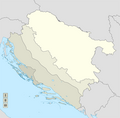
English: Locator Map of the German and Italian Occupation Zones in NDH 1941. Dashed line is the demarcation between German and Italian troops. Dotted line is the boundary of the Croatian demilitarised zone.
Date
Source

Anna Pizzuti - Ebrei stranieri internati in Italia durante il periodo bellico URL
Alberto Becherelli - Italia e Stato Indipendente Croato (1941-1943) URL
ZNACI.NET - TALIJANSKI DOKUMENTI - BROJ 164 NAREĐENJE KOMANDE 0. ARMIJSKOG KORPUSA OD 5. SVIBNJA 1941. POTCINJENIM JEDINICAMA ZA ORGANIZACIJU OKUPIRANE TERITORIJE U DALMACIJI1 URL

ZNACI.NET - TALIJANSKI DOKUMENTI - BROJ 168 SPORAZUM IZMEĐU NDH I FAŠISTIČKE ITALIJE OD 18. SVIBNJA 1941. O STVARANJU DEMILITARIZIRANE ZONE NA PODRUČJU NDH KOJA SE GRANICI S FAŠISTIČKOM ITALIJOM, O ODRICANJU NDH DA DRŽI RATNU MORNARICU I O PREVOŽENJU TRUPA FAŠISTIČKE ITALIJE PREKO TERITORIJE NDH URL
Author XrysD

Licensing

I, the copyright holder of this work, hereby publish it under the following license:
w:en:Creative Commons
attribution share alike
This file is licensed under the Creative Commons Attribution-Share Alike 4.0 International license.
You are free:
  • to share – to copy, distribute and transmit the work
  • to remix – to adapt the work
Under the following conditions:
  • attribution – You must give appropriate credit, provide a link to the license, and indicate if changes were made. You may do so in any reasonable manner, but not in any way that suggests the licensor endorses you or your use.
  • share alike – If you remix, transform, or build upon the material, you must distribute your contributions under the same or compatible license as the original.

Captions

German and Italian Occupation Zones in NDH 1941

Items portrayed in this file

depicts

29 February 2020

File history

Click on a date/time to view the file as it appeared at that time.

Date/TimeThumbnailDimensionsUserComment
current12:19, 8 March 2020Thumbnail for version as of 12:19, 8 March 20201,220 × 1,200 (328 KB)XrysDProjection changed to rectilinear. Occupation zones shaded and key added.
17:27, 29 February 2020Thumbnail for version as of 17:27, 29 February 20208,752 × 6,890 (577 KB)XrysDWrong line
16:06, 29 February 2020Thumbnail for version as of 16:06, 29 February 20208,752 × 6,890 (579 KB)XrysDUser created page with UploadWizard

The following 2 pages use this file:

Metadata